Ørje geodata
Ørje (Østfold) is a seat of a second-order administrative division; located in Norway in Europe/Oslo (GMT+2) time zone. With population of 1,722 people, there are 227 cities with bigger population in this country. Compared to other cities in Norway, 79.3% of cities are located further ↑North; 79.1% of cities are located further ←West and 71.7% of cities have lower elevation than Ørje. Note1


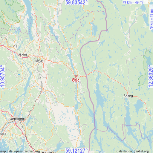
Ørje GPS coordinates[2]
59° 28' 48.828" North, 11° 39' 36.576" East
| Map corner | latitude | longitude |
|---|---|---|
| Upper-left | 59.83542°, | 10.95704° |
| Center: | 59.48023°, | 11.66016° |
| Lower-right: | 59.12127°, | 12.36329° |
| Map W x H: | 79.4×79.4 km | = 49.3×49.3mi |
| max Lat: | 71.04137° ⇑79.3% North |
| Ørje: | 59.48023° |
| min Lat: | ⇓20.7% South 58.0274° |
| min Long | Ørje | max Long |
| 4.71485° | 11.66016° | 31.11066° |
| W 79.1%⇐ | ⇒20.9% E |
Elevation
Elevation of Ørje is 133 m = 436 ft, and this is 28.8 m = 94 ft above average elevation for this country.
| Max E: |
897 m = 2943 ft | 28.3% |
| Ørje | 133 m 436 ft | |
| Avg. | 104.2 m = 342 ft | |
Min E: |
1 m = 3 ft | 71.7% |
See also: Norway elevation on elevation.city.
Geographical zone
Ørje is located in North temperate zone (between Tropic of Cancer and the Arctic Circle). Distance of this North polar circle is 787.6 km =489.4 mi to North.| Distance of | km | miles | from Ørje |
|---|---|---|---|
| North Pole | 3393.5 | 2108.6 | to North |
| Arctic Circle | 787.6 | 489.4 | to North |
| Tropic Cancer | 4007.7 | 2490.3 | to South |
| Equator | 6613.6 | 4109.5 | to South |


Nearby cities:
15 places around Ørje: (largest is in red/bold)
• Askim
30.3 km =18.8 mi,  292°
292°
• Fossby
28.8 km =17.9 mi,  175°
175°
• Fosser
39 km =24.2 mi,  345°
345°
• Heiås
31.8 km =19.8 mi,  320°
320°
• Hemnes
29.1 km =18.1 mi,  336°
336°
• Ise
31.9 km =19.8 mi,  231°
231°
• Knappstad
38.8 km =24.1 mi, 294°
• Løken
36.7 km =22.8 mi, 342°
• Meieribyen
28.2 km =17.5 mi,  268°
268°
• Mysen
20.5 km =12.7 mi, 293°
• Rakkestad
18.8 km =11.7 mi,  250°
250°
• Rømskog
31.1 km =19.3 mi,  15°
15°
• Sarpsborg
38.1 km =23.7 mi,  235°
235°
• Skjønhaug
26.4 km =16.4 mi,  312°
312°
• Spydeberg
35.8 km =22.2 mi,  295°
295°
Sources, notices
• [Note1] Compared only with cities in Norway existing in our database
• [Src1] Map data: © OpenStreetMap contributors (CC-BY-SA)
• [Src2] Other city data from geonames.org with taken over terms of usage.
• [Src3] Geographical zone / Annual Mean Temperature by Robert A. Rohde @ Wikipedia
