Søvik geodata
Søvik (Hordaland) is a populated place; located in Norway in Europe/Oslo (GMT+2) time zone. With population of 725 people, there are 374 cities with bigger population in this country. Compared to other cities in Norway, 59.7% of cities are located further ↑North; 92.2% of cities are located further →East and 54.9% of cities have lower elevation than Søvik. Note1


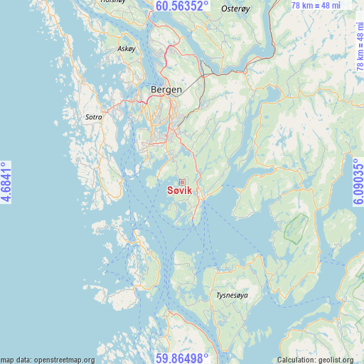
Søvik GPS coordinates[2]
60° 12' 57.996" North, 5° 23' 13.992" East
| Map corner | latitude | longitude |
|---|---|---|
| Upper-left | 60.56352°, | 4.6841° |
| Center: | 60.21611°, | 5.38722° |
| Lower-right: | 59.86498°, | 6.09035° |
| Map W x H: | 77.7×77.7 km | = 48.3×48.3mi |
| max Lat: | 71.04137° ⇑59.7% North |
| Søvik: | 60.21611° |
| min Lat: | ⇓40.3% South 58.0274° |
| min Long | Søvik | max Long |
| 4.71485° | 5.38722° | 31.11066° |
| W 7.8%⇐ | ⇒92.2% E |
Elevation
Elevation of Søvik is 60 m = 197 ft, and this is 44.2 m = 145 ft below average elevation for this country.
| Max E: |
897 m = 2943 ft | 45.1% |
| Avg. | 104.2 m = 342 ft | |
| Søvik | 60 m = 197 ft | |
Min E: |
1 m = 3 ft | 54.9% |
See also: Norway elevation on elevation.city.
Geographical zone
Søvik is located in North temperate zone (between Tropic of Cancer and the Arctic Circle). Distance of this North polar circle is 705.8 km =438.6 mi to North.| Distance of | km | miles | from Søvik |
|---|---|---|---|
| North Pole | 3311.7 | 2057.8 | to North |
| Arctic Circle | 705.8 | 438.6 | to North |
| Tropic Cancer | 4089.5 | 2541.1 | to South |
| Equator | 6695.4 | 4160.3 | to South |


Nearby cities:
15 places around Søvik: (largest is in red/bold)
• Bergen
20 km =12.4 mi,  349°
349°
• Eikelandsosen
19.9 km =12.4 mi,  81°
81°
• Espeland
19 km =11.8 mi,  13°
13°
• Hagavik
4 km =2.5 mi,  168°
168°
• Indre Arna
22.9 km =14.2 mi, 11°
• Kleppestø
23.1 km =14.4 mi,  337°
337°
• Klokkarvik
13.1 km =8.1 mi,  274°
274°
• Osøyro
5.5 km =3.4 mi,  130°
130°
• Sandsli
11.2 km =7 mi,  329°
329°
• Skogsvågen
16.4 km =10.2 mi,  285°
285°
• Storebø
16.1 km =10 mi,  213°
213°
• Straume
21.8 km =13.5 mi,  317°
317°
• Syfteland
4.4 km =2.7 mi,  56°
56°
• Våge
20.6 km =12.8 mi,  158°
158°
• Ytrebygda
11.5 km =7.1 mi, 329°
Sources, notices
• [Note1] Compared only with cities in Norway existing in our database
• [Src1] Map data: © OpenStreetMap contributors (CC-BY-SA)
• [Src2] Other city data from geonames.org with taken over terms of usage.
• [Src3] Geographical zone / Annual Mean Temperature by Robert A. Rohde @ Wikipedia
