Brønnøysund geodata
Brønnøysund (Nordland) is a seat of a second-order administrative division; located in Norway in Europe/Oslo (GMT+2) time zone. With population of 4,366 people, there are 101 cities with bigger population in this country. Compared to other cities in Norway, 83.4% of cities are located further ↓South; 82.6% of cities are located further ←West and 92.1% of cities have higher elevation than Brønnøysund. Note1


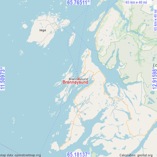
Brønnøysund GPS coordinates[2]
65° 28' 29.532" North, 12° 12' 46.26" East
| Map corner | latitude | longitude |
|---|---|---|
| Upper-left | 65.76511°, | 11.50973° |
| Center: | 65.47487°, | 12.21285° |
| Lower-right: | 65.18137°, | 12.91598° |
| Map W x H: | 64.9×64.9 km | = 40.3×40.3mi |
| max Lat: | 71.04137° ⇑16.6% North |
| Brønnøysund: | 65.47487° |
| min Lat: | ⇓83.4% South 58.0274° |
| min Long | Brønnøysund | max Long |
| 4.71485° | 12.21285° | 31.11066° |
| W 82.6%⇐ | ⇒17.4% E |
Elevation
Elevation of Brønnøysund is 3 m = 10 ft, and this is 101.2 m = 332 ft below average elevation for this country.
| Max E: |
897 m = 2943 ft | 92.1% |
| Avg. | 104.2 m = 342 ft | |
| Brønnøysund | 3 m = 10 ft | |
Min E: |
1 m = 3 ft | 7.9% |
See also: Norway elevation on elevation.city.
Geographical zone
Brønnøysund is located in North temperate zone (between Tropic of Cancer and the Arctic Circle). Distance of this North polar circle is 121.1 km =75.2 mi to North.| Distance of | km | miles | from Brønnøysund |
|---|---|---|---|
| North Pole | 2726.9 | 1694.4 | to North |
| Arctic Circle | 121.1 | 75.2 | to North |
| Tropic Cancer | 4674.2 | 2904.4 | to South |
| Equator | 7280.1 | 4523.6 | to South |


Nearby cities:
15 places around Brønnøysund: (largest is in red/bold)
• Gladstad
25.2 km =15.7 mi,  332°
332°
• Hattfjelldal
82.9 km =51.5 mi,  80°
80°
• Kolvereid
73.5 km =45.7 mi,  202°
202°
• Leknes
48 km =29.8 mi,  209°
209°
• Leland
73.5 km =45.7 mi,  26°
26°
• Mosjøen
60.2 km =37.4 mi,  48°
48°
• Namsskogan
75.1 km =46.7 mi,  143°
143°
• Rørvik
81.9 km =50.9 mi, 213°
• Sandnessjøen
63.7 km =39.6 mi,  17°
17°
• Silvalen
56.6 km =35.2 mi,  3°
3°
• Solfjellsjøen
72.4 km =45 mi,  9°
9°
• Terråk
43.8 km =27.2 mi,  170°
170°
• Trofors
55.4 km =34.4 mi, 83°
• Vevelstad
26.8 km =16.7 mi, 22°
• Vik
18.2 km =11.3 mi,  186°
186°
Sources, notices
• [Note1] Compared only with cities in Norway existing in our database
• [Src1] Map data: © OpenStreetMap contributors (CC-BY-SA)
• [Src2] Other city data from geonames.org with taken over terms of usage.
• [Src3] Geographical zone / Annual Mean Temperature by Robert A. Rohde @ Wikipedia
