Trofors geodata
Trofors (Nordland) is a seat of a second-order administrative division; located in Norway in Europe/Oslo (GMT+2) time zone. With population of 808 people, there are 356 cities with bigger population in this country. Compared to other cities in Norway, 83.5% of cities are located further ↓South; 85.6% of cities are located further ←West and 66% of cities have lower elevation than Trofors. Note1


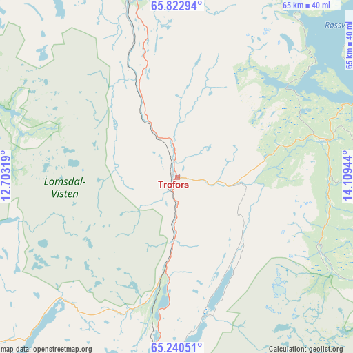
Trofors GPS coordinates[2]
65° 32' 0.06" North, 13° 24' 22.716" East
| Map corner | latitude | longitude |
|---|---|---|
| Upper-left | 65.82294°, | 12.70319° |
| Center: | 65.53335°, | 13.40631° |
| Lower-right: | 65.24051°, | 14.10944° |
| Map W x H: | 64.8×64.8 km | = 40.3×40.3mi |
| max Lat: | 71.04137° ⇑16.5% North |
| Trofors: | 65.53335° |
| min Lat: | ⇓83.5% South 58.0274° |
| min Long | Trofors | max Long |
| 4.71485° | 13.40631° | 31.11066° |
| W 85.6%⇐ | ⇒14.4% E |
Elevation
Elevation of Trofors is 100 m = 328 ft, and this is 4.2 m = 14 ft below average elevation for this country.
| Max E: |
897 m = 2943 ft | 34% |
| Avg. | 104.2 m = 342 ft | |
| Trofors | 100 m = 328 ft | |
Min E: |
1 m = 3 ft | 66% |
See also: Norway elevation on elevation.city.
Geographical zone
Trofors is located in North temperate zone (between Tropic of Cancer and the Arctic Circle). Distance of this North polar circle is 114.5 km =71.1 mi to North.| Distance of | km | miles | from Trofors |
|---|---|---|---|
| North Pole | 2720.4 | 1690.4 | to North |
| Arctic Circle | 114.5 | 71.1 | to North |
| Tropic Cancer | 4680.7 | 2908.5 | to South |
| Equator | 7286.6 | 4527.7 | to South |


Nearby cities:
15 places around Trofors: (largest is in red/bold)
• Brønnøysund
55.4 km =34.4 mi,  263°
263°
• Gladstad
68.2 km =42.4 mi,  283°
283°
• Hattfjelldal
27.7 km =17.2 mi,  75°
75°
• Korgen
63.3 km =39.3 mi,  17°
17°
• Leland
62.7 km =39 mi,  340°
340°
• Mosjøen
35.1 km =21.8 mi, 343°
• Namsskogan
68.2 km =42.4 mi,  189°
189°
• Nesna
76 km =47.2 mi,  346°
346°
• Røyrvik
72.6 km =45.1 mi,  174°
174°
• Sandnessjøen
64.8 km =40.3 mi,  326°
326°
• Silvalen
71.5 km =44.4 mi,  314°
314°
• Solfjellsjøen
77.3 km =48 mi, 327°
• Terråk
69.1 km =42.9 mi,  224°
224°
• Vevelstad
48.1 km =29.9 mi,  292°
292°
• Vik
62.3 km =38.7 mi,  246°
246°
Sources, notices
• [Note1] Compared only with cities in Norway existing in our database
• [Src1] Map data: © OpenStreetMap contributors (CC-BY-SA)
• [Src2] Other city data from geonames.org with taken over terms of usage.
• [Src3] Geographical zone / Annual Mean Temperature by Robert A. Rohde @ Wikipedia
