Fosser geodata
Fosser (Akershus) is a populated place; located in Norway in Europe/Oslo (GMT+2) time zone. With population of 557 people, there are 441 cities with bigger population in this country. Compared to other cities in Norway, 69.1% of cities are located further ↑North; 77.8% of cities are located further ←West and 73.4% of cities have lower elevation than Fosser. Note1


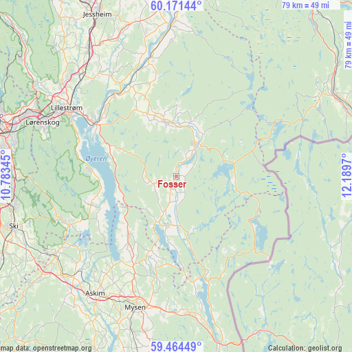
Fosser GPS coordinates[2]
59° 49' 11.424" North, 11° 29' 11.652" East
| Map corner | latitude | longitude |
|---|---|---|
| Upper-left | 60.17144°, | 10.78345° |
| Center: | 59.81984°, | 11.48657° |
| Lower-right: | 59.46449°, | 12.1897° |
| Map W x H: | 78.6×78.6 km | = 48.8×48.8mi |
| max Lat: | 71.04137° ⇑69.1% North |
| Fosser: | 59.81984° |
| min Lat: | ⇓30.9% South 58.0274° |
| min Long | Fosser | max Long |
| 4.71485° | 11.48657° | 31.11066° |
| W 77.8%⇐ | ⇒22.2% E |
Elevation
Elevation of Fosser is 138 m = 453 ft, and this is 33.8 m = 111 ft above average elevation for this country.
| Max E: |
897 m = 2943 ft | 26.6% |
| Fosser | 138 m 453 ft | |
| Avg. | 104.2 m = 342 ft | |
Min E: |
1 m = 3 ft | 73.4% |
See also: Norway elevation on elevation.city.
Geographical zone
Fosser is located in North temperate zone (between Tropic of Cancer and the Arctic Circle). Distance of this North polar circle is 749.8 km =465.9 mi to North.| Distance of | km | miles | from Fosser |
|---|---|---|---|
| North Pole | 3355.7 | 2085.1 | to North |
| Arctic Circle | 749.8 | 465.9 | to North |
| Tropic Cancer | 4045.4 | 2513.7 | to South |
| Equator | 6651.3 | 4132.9 | to South |


Nearby cities:
15 places around Fosser: (largest is in red/bold)
• Auli
24.9 km =15.5 mi,  343°
343°
• Aursmoen
12.2 km =7.6 mi,  348°
348°
• Bjørkelangen
8.3 km =5.2 mi,  31°
31°
• Fetsund
21.8 km =13.5 mi,  302°
302°
• Fjerdingby
26.3 km =16.3 mi, 296°
• Flateby
18.6 km =11.6 mi,  273°
273°
• Haga
26.8 km =16.7 mi, 346°
• Heiås
17 km =10.6 mi,  218°
218°
• Hemnes
11.1 km =6.9 mi,  189°
189°
• Kirkebygda
20.1 km =12.5 mi,  252°
252°
• Løken
2.9 km =1.8 mi,  203°
203°
• Lørenfallet
26.4 km =16.4 mi,  327°
327°
• Rømskog
19.8 km =12.3 mi,  113°
113°
• Skjønhaug
22.1 km =13.7 mi,  205°
205°
• Sørumsand
23 km =14.3 mi,  323°
323°
Sources, notices
• [Note1] Compared only with cities in Norway existing in our database
• [Src1] Map data: © OpenStreetMap contributors (CC-BY-SA)
• [Src2] Other city data from geonames.org with taken over terms of usage.
• [Src3] Geographical zone / Annual Mean Temperature by Robert A. Rohde @ Wikipedia
