Hemnes geodata
Hemnes (Akershus) is a populated place; located in Norway in Europe/Oslo (GMT+2) time zone. With population of 613 people, there are 411 cities with bigger population in this country. Compared to other cities in Norway, 72.6% of cities are located further ↑North; 77.1% of cities are located further ←West and 75.9% of cities have lower elevation than Hemnes. Note1


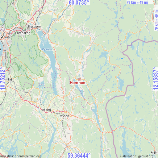
Hemnes GPS coordinates[2]
59° 43' 15.06" North, 11° 27' 18.864" East
| Map corner | latitude | longitude |
|---|---|---|
| Upper-left | 60.0735°, | 10.75212° |
| Center: | 59.72085°, | 11.45524° |
| Lower-right: | 59.36444°, | 12.15837° |
| Map W x H: | 78.8×78.8 km | = 49×49mi |
| max Lat: | 71.04137° ⇑72.6% North |
| Hemnes: | 59.72085° |
| min Lat: | ⇓27.4% South 58.0274° |
| min Long | Hemnes | max Long |
| 4.71485° | 11.45524° | 31.11066° |
| W 77.1%⇐ | ⇒22.9% E |
Elevation
Elevation of Hemnes is 149 m = 489 ft, and this is 44.8 m = 147 ft above average elevation for this country.
| Max E: |
897 m = 2943 ft | 24.1% |
| Hemnes | 149 m 489 ft | |
| Avg. | 104.2 m = 342 ft | |
Min E: |
1 m = 3 ft | 75.9% |
See also: Norway elevation on elevation.city.
Geographical zone
Hemnes is located in North temperate zone (between Tropic of Cancer and the Arctic Circle). Distance of this North polar circle is 760.8 km =472.7 mi to North.| Distance of | km | miles | from Hemnes |
|---|---|---|---|
| North Pole | 3366.7 | 2092 | to North |
| Arctic Circle | 760.8 | 472.7 | to North |
| Tropic Cancer | 4034.4 | 2506.9 | to South |
| Equator | 6640.3 | 4126.1 | to South |


Nearby cities:
15 places around Hemnes: (largest is in red/bold)
• Askim
22.4 km =13.9 mi,  227°
227°
• Aursmoen
23 km =14.3 mi,  358°
358°
• Bjørkelangen
19.1 km =11.9 mi,  18°
18°
• Fetsund
28.1 km =17.5 mi,  323°
323°
• Flateby
20.8 km =12.9 mi,  305°
305°
• Fosser
11.1 km =6.9 mi,  9°
9°
• Heiås
9.1 km =5.7 mi,  255°
255°
• Kirkebygda
18.1 km =11.2 mi,  285°
285°
• Knappstad
26 km =16.2 mi,  245°
245°
• Løken
8.3 km =5.2 mi,  4°
4°
• Mysen
20 km =12.4 mi,  201°
201°
• Rømskog
20.2 km =12.6 mi,  80°
80°
• Skjønhaug
11.9 km =7.4 mi,  221°
221°
• Spydeberg
23.7 km =14.7 mi,  240°
240°
• Tomter
26.7 km =16.6 mi, 255°
Sources, notices
• [Note1] Compared only with cities in Norway existing in our database
• [Src1] Map data: © OpenStreetMap contributors (CC-BY-SA)
• [Src2] Other city data from geonames.org with taken over terms of usage.
• [Src3] Geographical zone / Annual Mean Temperature by Robert A. Rohde @ Wikipedia
