Sola geodata
Sola (Rogaland) is a seat of a second-order administrative division; located in Norway in Europe/Oslo (GMT+2) time zone. In our database, there are 488 cities with bigger population. Compared to other cities in Norway, 91.3% of cities are located further ↑North; 88% of cities are located further →East and 79% of cities have higher elevation than Sola. Note1


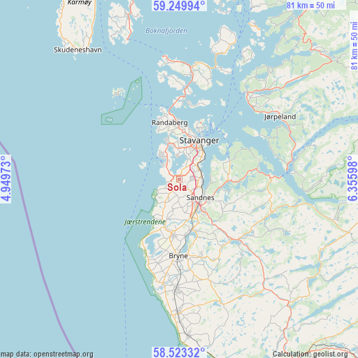
Sola GPS coordinates[2]
58° 53' 18.744" North, 5° 39' 10.26" East
| Map corner | latitude | longitude |
|---|---|---|
| Upper-left | 59.24994°, | 4.94973° |
| Center: | 58.88854°, | 5.65285° |
| Lower-right: | 58.52332°, | 6.35598° |
| Map W x H: | 80.8×80.8 km | = 50.2×50.2mi |
| max Lat: | 71.04137° ⇑91.3% North |
| Sola: | 58.88854° |
| min Lat: | ⇓8.7% South 58.0274° |
| min Long | Sola | max Long |
| 4.71485° | 5.65285° | 31.11066° |
| W 12%⇐ | ⇒88% E |
Elevation
Elevation of Sola is 11 m = 36 ft, and this is 93.2 m = 306 ft below average elevation for this country.
| Max E: |
897 m = 2943 ft | 79% |
| Avg. | 104.2 m = 342 ft | |
| Sola | 11 m = 36 ft | |
Min E: |
1 m = 3 ft | 21% |
See also: Norway elevation on elevation.city.
Geographical zone
Sola is located in North temperate zone (between Tropic of Cancer and the Arctic Circle). Distance of this North polar circle is 853.4 km =530.3 mi to North.| Distance of | km | miles | from Sola |
|---|---|---|---|
| North Pole | 3459.3 | 2149.5 | to North |
| Arctic Circle | 853.4 | 530.3 | to North |
| Tropic Cancer | 3941.9 | 2449.4 | to South |
| Equator | 6547.8 | 4068.6 | to South |


Nearby cities:
15 places around Sola: (largest is in red/bold)
• Bryne
17 km =10.6 mi,  181°
181°
• Forsand
26 km =16.2 mi,  86°
86°
• Hommersåk
12.1 km =7.5 mi,  70°
70°
• Kleppe
12.8 km =8 mi,  186°
186°
• Lyefjell
17.7 km =11 mi,  164°
164°
• Nærbø
24.8 km =15.4 mi, 181°
• Oltedal
23.1 km =14.4 mi,  106°
106°
• Randaberg
12.5 km =7.8 mi,  350°
350°
• Sandnes
6.2 km =3.9 mi,  130°
130°
• Stavanger
10.2 km =6.3 mi,  26°
26°
• Tananger
7 km =4.3 mi,  319°
319°
• Tau
25 km =15.5 mi,  38°
38°
• Vikevåg
23.4 km =14.5 mi,  6°
6°
• Ydstebøhamn
24.1 km =15 mi, 323°
• Ålgård
18 km =11.2 mi,  140°
140°
Sources, notices
• [Note1] Compared only with cities in Norway existing in our database
• [Src1] Map data: © OpenStreetMap contributors (CC-BY-SA)
• [Src2] Other city data from geonames.org with taken over terms of usage.
• [Src3] Geographical zone / Annual Mean Temperature by Robert A. Rohde @ Wikipedia
