Tananger geodata
Tananger (Rogaland) is a populated place; located in Norway in Europe/Oslo (GMT+2) time zone. With population of 5,817 people, there are 77 cities with bigger population in this country. Compared to other cities in Norway, 90.7% of cities are located further ↑North; 89.2% of cities are located further →East and 69.8% of cities have higher elevation than Tananger. Note1


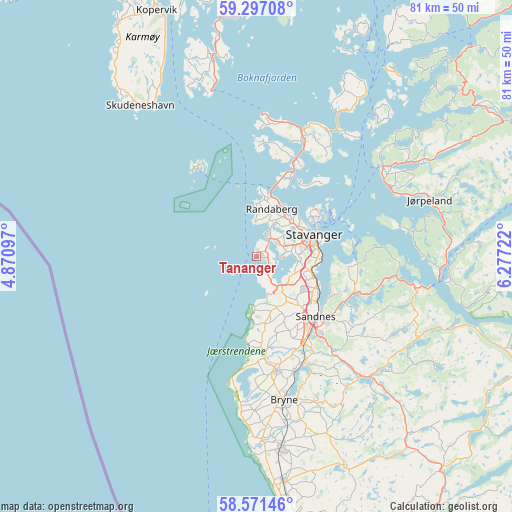
Tananger GPS coordinates[2]
58° 56' 10.248" North, 5° 34' 26.76" East
| Map corner | latitude | longitude |
|---|---|---|
| Upper-left | 59.29708°, | 4.87097° |
| Center: | 58.93618°, | 5.5741° |
| Lower-right: | 58.57146°, | 6.27722° |
| Map W x H: | 80.7×80.7 km | = 50.1×50.1mi |
| max Lat: | 71.04137° ⇑90.7% North |
| Tananger: | 58.93618° |
| min Lat: | ⇓9.3% South 58.0274° |
| min Long | Tananger | max Long |
| 4.71485° | 5.5741° | 31.11066° |
| W 10.8%⇐ | ⇒89.2% E |
Elevation
Elevation of Tananger is 19 m = 62 ft, and this is 85.2 m = 280 ft below average elevation for this country.
| Max E: |
897 m = 2943 ft | 69.8% |
| Avg. | 104.2 m = 342 ft | |
| Tananger | 19 m = 62 ft | |
Min E: |
1 m = 3 ft | 30.2% |
See also: Norway elevation on elevation.city.
Geographical zone
Tananger is located in North temperate zone (between Tropic of Cancer and the Arctic Circle). Distance of this North polar circle is 848.1 km =527 mi to North.| Distance of | km | miles | from Tananger |
|---|---|---|---|
| North Pole | 3454 | 2146.2 | to North |
| Arctic Circle | 848.1 | 527 | to North |
| Tropic Cancer | 3947.2 | 2452.7 | to South |
| Equator | 6553.1 | 4071.9 | to South |


Nearby cities:
15 places around Tananger: (largest is in red/bold)
• Bryne
22.7 km =14.1 mi,  169°
169°
• Hommersåk
15.9 km =9.9 mi,  94°
94°
• Jørpeland
28.4 km =17.6 mi,  70°
70°
• Kleppe
18.3 km =11.4 mi, 169°
• Lyefjell
24.2 km =15 mi,  157°
157°
• Oltedal
29.2 km =18.1 mi,  114°
114°
• Randaberg
7.5 km =4.7 mi,  19°
19°
• Sandnes
13.1 km =8.1 mi,  135°
135°
• Skudeneshavn
29.8 km =18.5 mi,  322°
322°
• Sola
7 km =4.3 mi, 139°
• Stavanger
9.9 km =6.2 mi, 67°
• Tau
24.5 km =15.2 mi,  54°
54°
• Vikevåg
19.3 km =12 mi, 21°
• Ydstebøhamn
17.1 km =10.6 mi, 324°
• Ålgård
24.9 km =15.5 mi, 140°
Sources, notices
• [Note1] Compared only with cities in Norway existing in our database
• [Src1] Map data: © OpenStreetMap contributors (CC-BY-SA)
• [Src2] Other city data from geonames.org with taken over terms of usage.
• [Src3] Geographical zone / Annual Mean Temperature by Robert A. Rohde @ Wikipedia
