Randaberg geodata
Randaberg (Rogaland) is a seat of a second-order administrative division; located in Norway in Europe/Oslo (GMT+2) time zone. In our database, there are 488 cities with bigger population. Compared to other cities in Norway, 90.3% of cities are located further ↑North; 88.8% of cities are located further →East and 55.1% of cities have higher elevation than Randaberg. Note1


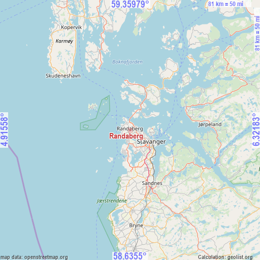
Randaberg GPS coordinates[2]
58° 59' 58.38" North, 5° 37' 7.356" East
| Map corner | latitude | longitude |
|---|---|---|
| Upper-left | 59.35979°, | 4.91558° |
| Center: | 58.99955°, | 5.61871° |
| Lower-right: | 58.6355°, | 6.32183° |
| Map W x H: | 80.5×80.5 km | = 50×50mi |
| max Lat: | 71.04137° ⇑90.3% North |
| Randaberg: | 58.99955° |
| min Lat: | ⇓9.7% South 58.0274° |
| min Long | Randaberg | max Long |
| 4.71485° | 5.61871° | 31.11066° |
| W 11.2%⇐ | ⇒88.8% E |
Elevation
Elevation of Randaberg is 34 m = 112 ft, and this is 70.2 m = 230 ft below average elevation for this country.
| Max E: |
897 m = 2943 ft | 55.1% |
| Avg. | 104.2 m = 342 ft | |
| Randaberg | 34 m = 112 ft | |
Min E: |
1 m = 3 ft | 44.9% |
See also: Norway elevation on elevation.city.
Geographical zone
Randaberg is located in North temperate zone (between Tropic of Cancer and the Arctic Circle). Distance of this North polar circle is 841 km =522.6 mi to North.| Distance of | km | miles | from Randaberg |
|---|---|---|---|
| North Pole | 3446.9 | 2141.8 | to North |
| Arctic Circle | 841 | 522.6 | to North |
| Tropic Cancer | 3954.2 | 2457 | to South |
| Equator | 6560.1 | 4076.3 | to South |


Nearby cities:
15 places around Randaberg: (largest is in red/bold)
• Bokn
27.7 km =17.2 mi,  337°
337°
• Bryne
29.4 km =18.3 mi,  176°
176°
• Hommersåk
15.7 km =9.8 mi,  121°
121°
• Judaberg
24.2 km =15 mi,  37°
37°
• Jørpeland
24.3 km =15.1 mi,  83°
83°
• Kleppe
25.1 km =15.6 mi, 178°
• Sandnes
17.7 km =11 mi,  157°
157°
• Skudeneshavn
26.5 km =16.5 mi,  308°
308°
• Sola
12.5 km =7.8 mi,  170°
170°
• Stavanger
7.3 km =4.5 mi, 116°
• Tananger
7.5 km =4.7 mi,  199°
199°
• Tau
18.8 km =11.7 mi,  67°
67°
• Vikevåg
11.8 km =7.3 mi,  22°
22°
• Ydstebøhamn
14.2 km =8.8 mi,  299°
299°
• Ålgård
29.4 km =18.3 mi,  152°
152°
Sources, notices
• [Note1] Compared only with cities in Norway existing in our database
• [Src1] Map data: © OpenStreetMap contributors (CC-BY-SA)
• [Src2] Other city data from geonames.org with taken over terms of usage.
• [Src3] Geographical zone / Annual Mean Temperature by Robert A. Rohde @ Wikipedia
