Hommersåk geodata
Hommersåk (Rogaland) is a populated locality; located in Norway in Europe/Oslo (GMT+2) time zone. With population of 5,692 people, there are 79 cities with bigger population in this country. Compared to other cities in Norway, 90.8% of cities are located further ↑North; 84.8% of cities are located further →East and 69.8% of cities have higher elevation than Hommersåk. Note1


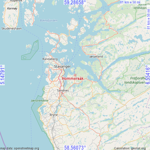
Hommersåk GPS coordinates[2]
58° 55' 32.016" North, 5° 51' 3.744" East
| Map corner | latitude | longitude |
|---|---|---|
| Upper-left | 59.28658°, | 5.14791° |
| Center: | 58.92556°, | 5.85104° |
| Lower-right: | 58.56073°, | 6.55416° |
| Map W x H: | 80.7×80.7 km | = 50.1×50.1mi |
| max Lat: | 71.04137° ⇑90.8% North |
| Hommersåk: | 58.92556° |
| min Lat: | ⇓9.2% South 58.0274° |
| min Long | Hommersåk | max Long |
| 4.71485° | 5.85104° | 31.11066° |
| W 15.2%⇐ | ⇒84.8% E |
Elevation
Elevation of Hommersåk is 19 m = 62 ft, and this is 85.2 m = 280 ft below average elevation for this country.
| Max E: |
897 m = 2943 ft | 69.8% |
| Avg. | 104.2 m = 342 ft | |
| Hommersåk | 19 m = 62 ft | |
Min E: |
1 m = 3 ft | 30.2% |
See also: Norway elevation on elevation.city.
Geographical zone
Hommersåk is located in North temperate zone (between Tropic of Cancer and the Arctic Circle). Distance of this North polar circle is 849.3 km =527.7 mi to North.| Distance of | km | miles | from Hommersåk |
|---|---|---|---|
| North Pole | 3455.2 | 2147 | to North |
| Arctic Circle | 849.3 | 527.7 | to North |
| Tropic Cancer | 3946 | 2451.9 | to South |
| Equator | 6551.9 | 4071.2 | to South |


Nearby cities:
15 places around Hommersåk: (largest is in red/bold)
• Bryne
24.2 km =15 mi,  208°
208°
• Forsand
14.8 km =9.2 mi,  99°
99°
• Judaberg
27.4 km =17 mi,  3°
3°
• Jørpeland
15.3 km =9.5 mi,  45°
45°
• Kleppe
21.1 km =13.1 mi,  217°
217°
• Lyefjell
22.2 km =13.8 mi,  197°
197°
• Oltedal
15.2 km =9.4 mi,  135°
135°
• Randaberg
15.7 km =9.8 mi,  301°
301°
• Sandnes
10.5 km =6.5 mi, 219°
• Sola
12.1 km =7.5 mi,  250°
250°
• Stavanger
8.4 km =5.2 mi,  306°
306°
• Tananger
15.9 km =9.9 mi,  274°
274°
• Tau
16 km =9.9 mi,  14°
14°
• Vikevåg
21 km =13 mi,  335°
335°
• Ålgård
17.9 km =11.1 mi,  179°
179°
Sources, notices
• [Note1] Compared only with cities in Norway existing in our database
• [Src1] Map data: © OpenStreetMap contributors (CC-BY-SA)
• [Src2] Other city data from geonames.org with taken over terms of usage.
• [Src3] Geographical zone / Annual Mean Temperature by Robert A. Rohde @ Wikipedia
