Tau geodata
Tau (Rogaland) is a populated place; located in Norway in Europe/Oslo (GMT+2) time zone. With population of 2,548 people, there are 148 cities with bigger population in this country. Compared to other cities in Norway, 89.1% of cities are located further ↑North; 83.7% of cities are located further →East and 61.1% of cities have higher elevation than Tau. Note1


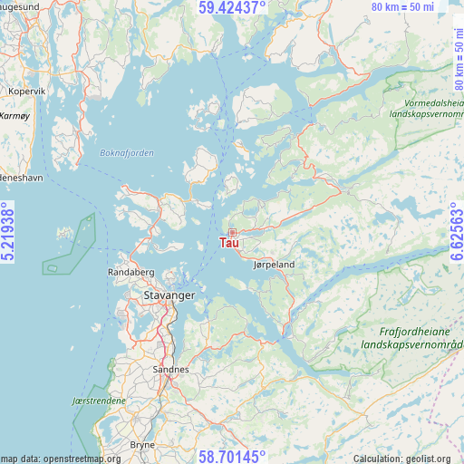
Tau GPS coordinates[2]
59° 3' 53.316" North, 5° 55' 21" East
| Map corner | latitude | longitude |
|---|---|---|
| Upper-left | 59.42437°, | 5.21938° |
| Center: | 59.06481°, | 5.9225° |
| Lower-right: | 58.70145°, | 6.62563° |
| Map W x H: | 80.4×80.4 km | = 50×50mi |
| max Lat: | 71.04137° ⇑89.1% North |
| Tau: | 59.06481° |
| min Lat: | ⇓10.9% South 58.0274° |
| min Long | Tau | max Long |
| 4.71485° | 5.9225° | 31.11066° |
| W 16.3%⇐ | ⇒83.7% E |
Elevation
Elevation of Tau is 26 m = 85 ft, and this is 78.2 m = 257 ft below average elevation for this country.
| Max E: |
897 m = 2943 ft | 61.1% |
| Avg. | 104.2 m = 342 ft | |
| Tau | 26 m = 85 ft | |
Min E: |
1 m = 3 ft | 38.9% |
See also: Norway elevation on elevation.city.
Geographical zone
Tau is located in North temperate zone (between Tropic of Cancer and the Arctic Circle). Distance of this North polar circle is 833.8 km =518.1 mi to North.| Distance of | km | miles | from Tau |
|---|---|---|---|
| North Pole | 3439.7 | 2137.3 | to North |
| Arctic Circle | 833.8 | 518.1 | to North |
| Tropic Cancer | 3961.5 | 2461.6 | to South |
| Equator | 6567.4 | 4080.8 | to South |


Nearby cities:
15 places around Tau: (largest is in red/bold)
• Bokn
33.3 km =20.7 mi,  303°
303°
• Forsand
20.8 km =12.9 mi,  149°
149°
• Hjelmelandsvågen
24.1 km =15 mi,  37°
37°
• Hommersåk
16 km =9.9 mi,  194°
194°
• Judaberg
12.2 km =7.6 mi,  347°
347°
• Jørpeland
8.2 km =5.1 mi,  124°
124°
• Oltedal
27.1 km =16.8 mi,  165°
165°
• Randaberg
18.8 km =11.7 mi,  247°
247°
• Sandnes
25.9 km =16.1 mi,  204°
204°
• Sola
25 km =15.5 mi,  218°
218°
• Stavanger
15.1 km =9.4 mi,  225°
225°
• Tananger
24.5 km =15.2 mi, 234°
• Vikevåg
13.3 km =8.3 mi,  285°
285°
• Ydstebøhamn
29.7 km =18.5 mi,  269°
269°
• Ålgård
33.7 km =20.9 mi, 186°
Sources, notices
• [Note1] Compared only with cities in Norway existing in our database
• [Src1] Map data: © OpenStreetMap contributors (CC-BY-SA)
• [Src2] Other city data from geonames.org with taken over terms of usage.
• [Src3] Geographical zone / Annual Mean Temperature by Robert A. Rohde @ Wikipedia
