Sandnes geodata
Sandnes (Rogaland) is a seat of a second-order administrative division; located in Norway in Europe/Oslo (GMT+2) time zone. With population of 63,032 people, there are 7 cities with bigger population in this country. Compared to other cities in Norway, 91.8% of cities are located further ↑North; 86.9% of cities are located further →East and 84.8% of cities have higher elevation than Sandnes. Note1


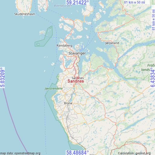
Sandnes GPS coordinates[2]
58° 51' 8.784" North, 5° 44' 6.756" East
| Map corner | latitude | longitude |
|---|---|---|
| Upper-left | 59.21422°, | 5.03209° |
| Center: | 58.85244°, | 5.73521° |
| Lower-right: | 58.48684°, | 6.43834° |
| Map W x H: | 80.9×80.9 km | = 50.3×50.3mi |
| max Lat: | 71.04137° ⇑91.8% North |
| Sandnes: | 58.85244° |
| min Lat: | ⇓8.2% South 58.0274° |
| min Long | Sandnes | max Long |
| 4.71485° | 5.73521° | 31.11066° |
| W 13.1%⇐ | ⇒86.9% E |
Elevation
Elevation of Sandnes is 8 m = 26 ft, and this is 96.2 m = 316 ft below average elevation for this country.
| Max E: |
897 m = 2943 ft | 84.8% |
| Avg. | 104.2 m = 342 ft | |
| Sandnes | 8 m = 26 ft | |
Min E: |
1 m = 3 ft | 15.2% |
See also: Sandnes elevation on elevation.city.
Geographical zone
Sandnes is located in North temperate zone (between Tropic of Cancer and the Arctic Circle). Distance of this North polar circle is 857.4 km =532.8 mi to North.| Distance of | km | miles | from Sandnes |
|---|---|---|---|
| North Pole | 3463.3 | 2152 | to North |
| Arctic Circle | 857.4 | 532.8 | to North |
| Tropic Cancer | 3937.9 | 2446.9 | to South |
| Equator | 6543.8 | 4066.1 | to South |


Nearby cities:
15 places around Sandnes: (largest is in red/bold)
• Bryne
14 km =8.7 mi,  201°
201°
• Forsand
22 km =13.7 mi,  75°
75°
• Hommersåk
10.5 km =6.5 mi,  39°
39°
• Jørpeland
25.8 km =16 mi, 42°
• Kleppe
10.6 km =6.6 mi,  215°
215°
• Lyefjell
13 km =8.1 mi,  179°
179°
• Nærbø
21.5 km =13.4 mi, 195°
• Oltedal
17.6 km =10.9 mi,  98°
98°
• Randaberg
17.7 km =11 mi,  337°
337°
• Sola
6.2 km =3.9 mi,  310°
310°
• Stavanger
13.1 km =8.1 mi,  359°
359°
• Tananger
13.1 km =8.1 mi,  315°
315°
• Tau
25.9 km =16.1 mi,  24°
24°
• Varhaug
26.4 km =16.4 mi,  189°
189°
• Ålgård
11.9 km =7.4 mi,  145°
145°
Sources, notices
• [Note1] Compared only with cities in Norway existing in our database
• [Src1] Map data: © OpenStreetMap contributors (CC-BY-SA)
• [Src2] Other city data from geonames.org with taken over terms of usage.
• [Src3] Geographical zone / Annual Mean Temperature by Robert A. Rohde @ Wikipedia
