Jøa geodata
Jøa (Trøndelag) is a seat of a second-order administrative division; located in Norway in Europe/Oslo (GMT+2) time zone. In our database, there are 488 cities with bigger population. Compared to other cities in Norway, 82.1% of cities are located further ↓South; 73.9% of cities are located further ←West and 82.6% of cities have lower elevation than Jøa. Note1


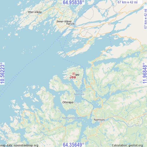
Jøa GPS coordinates[2]
64° 39' 32.76" North, 11° 15' 55.26" East
| Map corner | latitude | longitude |
|---|---|---|
| Upper-left | 64.95838°, | 10.56223° |
| Center: | 64.6591°, | 11.26535° |
| Lower-right: | 64.35649°, | 11.96848° |
| Map W x H: | 66.9×66.9 km | = 41.6×41.6mi |
| max Lat: | 71.04137° ⇑17.9% North |
| Jøa: | 64.6591° |
| min Lat: | ⇓82.1% South 58.0274° |
| min Long | Jøa | max Long |
| 4.71485° | 11.26535° | 31.11066° |
| W 73.9%⇐ | ⇒26.1% E |
Elevation
Elevation of Jøa is 190 m = 623 ft, and this is 85.8 m = 281 ft above average elevation for this country.
| Max E: |
897 m = 2943 ft | 17.4% |
| Jøa | 190 m 623 ft | |
| Avg. | 104.2 m = 342 ft | |
Min E: |
1 m = 3 ft | 82.6% |
See also: Norway elevation on elevation.city.
Geographical zone
Jøa is located in North temperate zone (between Tropic of Cancer and the Arctic Circle). Distance of this North polar circle is 211.8 km =131.6 mi to North.| Distance of | km | miles | from Jøa |
|---|---|---|---|
| North Pole | 2817.6 | 1750.8 | to North |
| Arctic Circle | 211.8 | 131.6 | to North |
| Tropic Cancer | 4583.5 | 2848.1 | to South |
| Equator | 7189.4 | 4467.3 | to South |


Nearby cities:
15 places around Jøa: (largest is in red/bold)
• Bangsund
30.3 km =18.8 mi,  168°
168°
• Grong
54.6 km =33.9 mi,  113°
113°
• Høylandet
49.5 km =30.8 mi,  93°
93°
• Kolvereid
28 km =17.4 mi,  35°
35°
• Lauvsnes
25 km =15.5 mi,  225°
225°
• Leknes
53.1 km =33 mi,  22°
22°
• Malm
64.9 km =40.3 mi,  181°
181°
• Namdalseid
48.7 km =30.3 mi, 182°
• Namsos
24.1 km =15 mi,  152°
152°
• Ranemsletta
37.4 km =23.2 mi,  119°
119°
• Rørvik
22.6 km =14 mi,  356°
356°
• Skage
31.7 km =19.7 mi,  132°
132°
• Snåase
70.4 km =43.7 mi, 130°
• Steinsdalen
53.9 km =33.5 mi,  221°
221°
• Terråk
70.6 km =43.9 mi,  47°
47°
Sources, notices
• [Note1] Compared only with cities in Norway existing in our database
• [Src1] Map data: © OpenStreetMap contributors (CC-BY-SA)
• [Src2] Other city data from geonames.org with taken over terms of usage.
• [Src3] Geographical zone / Annual Mean Temperature by Robert A. Rohde @ Wikipedia
