Bangsund geodata
Bangsund (Trøndelag) is a populated place; located in Norway in Europe/Oslo (GMT+2) time zone. With population of 878 people, there are 339 cities with bigger population in this country. Compared to other cities in Norway, 80.9% of cities are located further ↓South; 76.6% of cities are located further ←West and 69% of cities have higher elevation than Bangsund. Note1


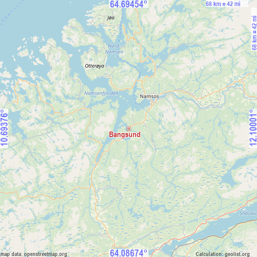
Bangsund GPS coordinates[2]
64° 23' 32.352" North, 11° 23' 48.768" East
| Map corner | latitude | longitude |
|---|---|---|
| Upper-left | 64.69454°, | 10.69376° |
| Center: | 64.39232°, | 11.39688° |
| Lower-right: | 64.08674°, | 12.10001° |
| Map W x H: | 67.6×67.6 km | = 42×42mi |
| max Lat: | 71.04137° ⇑19.1% North |
| Bangsund: | 64.39232° |
| min Lat: | ⇓80.9% South 58.0274° |
| min Long | Bangsund | max Long |
| 4.71485° | 11.39688° | 31.11066° |
| W 76.6%⇐ | ⇒23.4% E |
Elevation
Elevation of Bangsund is 20 m = 66 ft, and this is 84.2 m = 276 ft below average elevation for this country.
| Max E: |
897 m = 2943 ft | 69% |
| Avg. | 104.2 m = 342 ft | |
| Bangsund | 20 m = 66 ft | |
Min E: |
1 m = 3 ft | 31% |
See also: Norway elevation on elevation.city.
Geographical zone
Bangsund is located in North temperate zone (between Tropic of Cancer and the Arctic Circle). Distance of this North polar circle is 241.4 km =150 mi to North.| Distance of | km | miles | from Bangsund |
|---|---|---|---|
| North Pole | 2847.3 | 1769.2 | to North |
| Arctic Circle | 241.4 | 150 | to North |
| Tropic Cancer | 4553.8 | 2829.6 | to South |
| Equator | 7159.8 | 4448.9 | to South |


Nearby cities:
15 places around Bangsund: (largest is in red/bold)
• Grong
44.8 km =27.8 mi,  79°
79°
• Høylandet
50.7 km =31.5 mi,  58°
58°
• Jøa
30.3 km =18.8 mi,  348°
348°
• Kolvereid
53.5 km =33.2 mi,  10°
10°
• Lauvsnes
27 km =16.8 mi,  296°
296°
• Malm
36.2 km =22.5 mi,  193°
193°
• Namdalseid
20.7 km =12.9 mi,  203°
203°
• Namsos
9.5 km =5.9 mi,  29°
29°
• Ranemsletta
28.8 km =17.9 mi,  66°
66°
• Rørvik
52.7 km =32.7 mi, 351°
• Skage
19.2 km =11.9 mi, 64°
• Snåase
50 km =31.1 mi,  109°
109°
• Sparbu
52.7 km =32.7 mi,  178°
178°
• Steinkjer
42.2 km =26.2 mi,  173°
173°
• Steinsdalen
43.8 km =27.2 mi,  256°
256°
Sources, notices
• [Note1] Compared only with cities in Norway existing in our database
• [Src1] Map data: © OpenStreetMap contributors (CC-BY-SA)
• [Src2] Other city data from geonames.org with taken over terms of usage.
• [Src3] Geographical zone / Annual Mean Temperature by Robert A. Rohde @ Wikipedia
