Kvalsund geodata
Kvalsund (Finnmark) is a seat of a second-order administrative division; located in Norway in Europe/Oslo (GMT+2) time zone. In our database, there are 488 cities with bigger population. Compared to other cities in Norway, 98.6% of cities are located further ↓South; 97.8% of cities are located further ←West and 100% of cities have higher elevation than Kvalsund. Note1


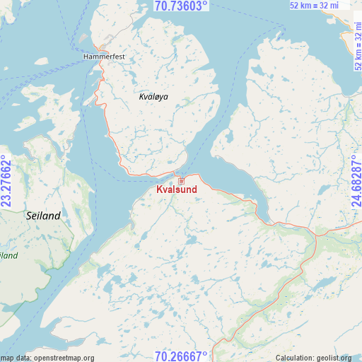
Kvalsund GPS coordinates[2]
70° 30' 9.756" North, 23° 58' 47.064" East
| Map corner | latitude | longitude |
|---|---|---|
| Upper-left | 70.73603°, | 23.27662° |
| Center: | 70.50271°, | 23.97974° |
| Lower-right: | 70.26667°, | 24.68287° |
| Map W x H: | 52.2×52.2 km | = 32.4×32.4mi |
| max Lat: | 71.04137° ⇑1.4% North |
| Kvalsund: | 70.50271° |
| min Lat: | ⇓98.6% South 58.0274° |
| min Long | Kvalsund | max Long |
| 4.71485° | 23.97974° | 31.11066° |
| W 97.8%⇐ | ⇒2.2% E |
Elevation
Elevation of Kvalsund is 1 m = 3 ft, and this is 103.2 m = 339 ft below average elevation for this country.
| Max E: |
897 m = 2943 ft | 100% |
| Avg. | 104.2 m = 342 ft | |
| Kvalsund | 1 m = 3 ft | |
Min E: |
1 m = 3 ft | 0% |
See also: Norway elevation on elevation.city.
Geographical zone
Kvalsund is located in North Frigid zone (between North Pole and Arctic Circle). Distance of this North polar circle is 438 km =272.2 mi to South.| Distance of | km | miles | from Kvalsund |
|---|---|---|---|
| North Pole | 2167.9 | 1347.1 | to North |
| Arctic Circle | 438 | 272.2 | to South |
| Tropic Cancer | 5233.2 | 3251.8 | to South |
| Equator | 7839.2 | 4871.1 | to South |


Nearby cities:
15 places around Kvalsund: (largest is in red/bold)
• Alta
65.1 km =40.5 mi,  204°
204°
• Breivikbotn
63.4 km =39.4 mi,  278°
278°
• Burfjord
95.9 km =59.6 mi,  229°
229°
• Hammerfest
21 km =13 mi,  328°
328°
• Honningsvåg
90.4 km =56.2 mi,  53°
53°
• Kjøllefjord
133 km =82.6 mi,  68°
68°
• Kárášjohka
128.6 km =79.9 mi,  153°
153°
• Lakselv
62.5 km =38.8 mi,  143°
143°
• Mehamn
153.9 km =95.6 mi, 67°
• Olderdalen
164.5 km =102.2 mi, 232°
• Rypefjord
19.2 km =11.9 mi,  323°
323°
• Skjervøy
124.5 km =77.4 mi,  245°
245°
• Storslett
138.3 km =85.9 mi, 233°
• Ávanuorri
60.3 km =37.5 mi,  24°
24°
• Øksfjord
67.5 km =41.9 mi,  244°
244°
Sources, notices
• [Note1] Compared only with cities in Norway existing in our database
• [Src1] Map data: © OpenStreetMap contributors (CC-BY-SA)
• [Src2] Other city data from geonames.org with taken over terms of usage.
• [Src3] Geographical zone / Annual Mean Temperature by Robert A. Rohde @ Wikipedia
