Lakselv geodata
Lakselv (Finnmark) is a seat of a second-order administrative division; located in Norway in Europe/Oslo (GMT+2) time zone. With population of 2,168 people, there are 182 cities with bigger population in this country. Compared to other cities in Norway, 97.6% of cities are located further ↓South; 98.1% of cities are located further ←West and 77.8% of cities have higher elevation than Lakselv. Note1


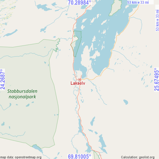
Lakselv GPS coordinates[2]
70° 3' 4.788" North, 24° 58' 18.552" East
| Map corner | latitude | longitude |
|---|---|---|
| Upper-left | 70.28984°, | 24.2687° |
| Center: | 70.05133°, | 24.97182° |
| Lower-right: | 69.81005°, | 25.67495° |
| Map W x H: | 53.3×53.3 km | = 33.1×33.1mi |
| max Lat: | 71.04137° ⇑2.4% North |
| Lakselv: | 70.05133° |
| min Lat: | ⇓97.6% South 58.0274° |
| min Long | Lakselv | max Long |
| 4.71485° | 24.97182° | 31.11066° |
| W 98.1%⇐ | ⇒1.9% E |
Elevation
Elevation of Lakselv is 12 m = 39 ft, and this is 92.2 m = 302 ft below average elevation for this country.
| Max E: |
897 m = 2943 ft | 77.8% |
| Avg. | 104.2 m = 342 ft | |
| Lakselv | 12 m = 39 ft | |
Min E: |
1 m = 3 ft | 22.2% |
See also: Norway elevation on elevation.city.
Geographical zone
Lakselv is located in North Frigid zone (between North Pole and Arctic Circle). Distance of this North polar circle is 387.8 km =241 mi to South.| Distance of | km | miles | from Lakselv |
|---|---|---|---|
| North Pole | 2218.1 | 1378.3 | to North |
| Arctic Circle | 387.8 | 241 | to South |
| Tropic Cancer | 5183.1 | 3220.6 | to South |
| Equator | 7789 | 4839.9 | to South |


Nearby cities:
15 places around Lakselv: (largest is in red/bold)
• Alta
65.3 km =40.6 mi,  261°
261°
• Breivikbotn
116.9 km =72.6 mi,  300°
300°
• Burfjord
111.8 km =69.5 mi, 263°
• Hammerfest
83.4 km =51.8 mi,  324°
324°
• Honningsvåg
109.9 km =68.3 mi,  19°
19°
• Kautokeino
137.7 km =85.6 mi,  213°
213°
• Kjøllefjord
132.9 km =82.6 mi,  41°
41°
• Kvalsund
62.5 km =38.8 mi, 323°
• Kárášjohka
67.7 km =42.1 mi,  162°
162°
• Mehamn
153.2 km =95.2 mi, 44°
• Rypefjord
81.6 km =50.7 mi, 323°
• Tana bru
122.8 km =76.3 mi,  82°
82°
• Vuonnabahta
136.2 km =84.6 mi, 84°
• Ávanuorri
105.7 km =65.7 mi,  353°
353°
• Øksfjord
101.2 km =62.9 mi,  281°
281°
Sources, notices
• [Note1] Compared only with cities in Norway existing in our database
• [Src1] Map data: © OpenStreetMap contributors (CC-BY-SA)
• [Src2] Other city data from geonames.org with taken over terms of usage.
• [Src3] Geographical zone / Annual Mean Temperature by Robert A. Rohde @ Wikipedia
