Alta geodata
Alta (Finnmark) is a seat of a second-order administrative division; located in Norway in Europe/Oslo (GMT+2) time zone. With population of 12,077 people, there are 41 cities with bigger population in this country. Compared to other cities in Norway, 97.3% of cities are located further ↓South; 97.3% of cities are located further ←West and 59.8% of cities have lower elevation than Alta. Note1


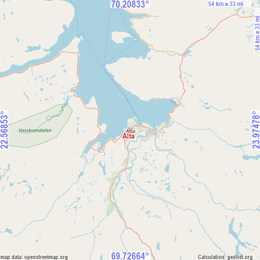
Alta GPS coordinates[2]
69° 58' 7.932" North, 23° 16' 17.94" East
| Map corner | latitude | longitude |
|---|---|---|
| Upper-left | 70.20833°, | 22.56853° |
| Center: | 69.96887°, | 23.27165° |
| Lower-right: | 69.72664°, | 23.97478° |
| Map W x H: | 53.6×53.6 km | = 33.3×33.3mi |
| max Lat: | 71.04137° ⇑2.7% North |
| Alta: | 69.96887° |
| min Lat: | ⇓97.3% South 58.0274° |
| min Long | Alta | max Long |
| 4.71485° | 23.27165° | 31.11066° |
| W 97.3%⇐ | ⇒2.7% E |
Elevation
Elevation of Alta is 65 m = 213 ft, and this is 39.2 m = 129 ft below average elevation for this country.
| Max E: |
897 m = 2943 ft | 40.2% |
| Avg. | 104.2 m = 342 ft | |
| Alta | 65 m = 213 ft | |
Min E: |
1 m = 3 ft | 59.8% |
See also: Norway elevation on elevation.city.
Geographical zone
Alta is located in North Frigid zone (between North Pole and Arctic Circle). Distance of this North polar circle is 378.6 km =235.3 mi to South.| Distance of | km | miles | from Alta |
|---|---|---|---|
| North Pole | 2227.3 | 1384 | to North |
| Arctic Circle | 378.6 | 235.3 | to South |
| Tropic Cancer | 5173.9 | 3214.9 | to South |
| Equator | 7779.8 | 4834.1 | to South |


Nearby cities:
15 places around Alta: (largest is in red/bold)
• Breivikbotn
78.2 km =48.6 mi,  331°
331°
• Burfjord
46.6 km =29 mi,  265°
265°
• Hammerfest
78.7 km =48.9 mi,  11°
11°
• Hansnes
138.8 km =86.2 mi, 269°
• Kautokeino
106.7 km =66.3 mi,  184°
184°
• Kvalsund
65.1 km =40.5 mi,  24°
24°
• Kárášjohka
102.5 km =63.7 mi,  122°
122°
• Lakselv
65.3 km =40.6 mi,  81°
81°
• Lyngseidet
125.2 km =77.8 mi,  249°
249°
• Olderdalen
112.8 km =70.1 mi, 248°
• Rypefjord
76.3 km =47.4 mi, 11°
• Skjervøy
87.7 km =54.5 mi, 274°
• Storslett
88.8 km =55.2 mi,  255°
255°
• Ávanuorri
125.4 km =77.9 mi, 24°
• Øksfjord
46 km =28.6 mi,  310°
310°
Sources, notices
• [Note1] Compared only with cities in Norway existing in our database
• [Src1] Map data: © OpenStreetMap contributors (CC-BY-SA)
• [Src2] Other city data from geonames.org with taken over terms of usage.
• [Src3] Geographical zone / Annual Mean Temperature by Robert A. Rohde @ Wikipedia
