Hammerfest geodata
Hammerfest (Finnmark) is a seat of a second-order administrative division; located in Norway in Europe/Oslo (GMT+2) time zone. With population of 6,788 people, there are 65 cities with bigger population in this country. Compared to other cities in Norway, 99.2% of cities are located further ↓South; 97.6% of cities are located further ←West and 52.7% of cities have higher elevation than Hammerfest. Note1


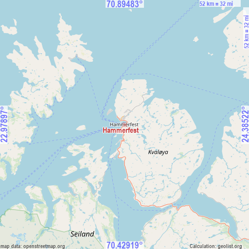
Hammerfest GPS coordinates[2]
70° 39' 48.096" North, 23° 40' 55.524" East
| Map corner | latitude | longitude |
|---|---|---|
| Upper-left | 70.89483°, | 22.97897° |
| Center: | 70.66336°, | 23.68209° |
| Lower-right: | 70.42919°, | 24.38522° |
| Map W x H: | 51.8×51.8 km | = 32.2×32.2mi |
| max Lat: | 71.04137° ⇑0.8% North |
| Hammerfest: | 70.66336° |
| min Lat: | ⇓99.2% South 58.0274° |
| min Long | Hammerfest | max Long |
| 4.71485° | 23.68209° | 31.11066° |
| W 97.6%⇐ | ⇒2.4% E |
Elevation
Elevation of Hammerfest is 40 m = 131 ft, and this is 64.2 m = 211 ft below average elevation for this country.
| Max E: |
897 m = 2943 ft | 52.7% |
| Avg. | 104.2 m = 342 ft | |
| Hammerfest | 40 m = 131 ft | |
Min E: |
1 m = 3 ft | 47.3% |
See also: Norway elevation on elevation.city.
Geographical zone
Hammerfest is located in North Frigid zone (between North Pole and Arctic Circle). Distance of this North polar circle is 455.9 km =283.3 mi to South.| Distance of | km | miles | from Hammerfest |
|---|---|---|---|
| North Pole | 2150 | 1335.9 | to North |
| Arctic Circle | 455.9 | 283.3 | to South |
| Tropic Cancer | 5251.1 | 3262.9 | to South |
| Equator | 7857 | 4882.1 | to South |


Nearby cities:
15 places around Hammerfest: (largest is in red/bold)
• Alta
78.7 km =48.9 mi,  191°
191°
• Breivikbotn
52.1 km =32.4 mi,  260°
260°
• Burfjord
101.2 km =62.9 mi,  217°
217°
• Honningsvåg
90.8 km =56.4 mi,  67°
67°
• Kjøllefjord
137.6 km =85.5 mi,  76°
76°
• Kvalsund
21 km =13 mi,  148°
148°
• Kárášjohka
149.5 km =92.9 mi, 152°
• Lakselv
83.4 km =51.8 mi,  144°
144°
• Lyngseidet
178.2 km =110.7 mi,  227°
227°
• Olderdalen
167.4 km =104 mi, 225°
• Rypefjord
2.5 km =1.6 mi, 188°
• Skjervøy
123.3 km =76.6 mi,  235°
235°
• Storslett
141.1 km =87.7 mi, 225°
• Ávanuorri
51.5 km =32 mi,  44°
44°
• Øksfjord
68.4 km =42.5 mi, 226°
Sources, notices
• [Note1] Compared only with cities in Norway existing in our database
• [Src1] Map data: © OpenStreetMap contributors (CC-BY-SA)
• [Src2] Other city data from geonames.org with taken over terms of usage.
• [Src3] Geographical zone / Annual Mean Temperature by Robert A. Rohde @ Wikipedia
