Panauti̇̄ geodata
Panauti̇̄ (Central Region) is a populated place; located in Nepal in Asia/Kathmandu (GMT+5.75) time zone. With population of 27,602 people, there are 26 cities with bigger population in this country. Compared to other cities in Nepal, 71.6% of cities are located further ↑North; 66.2% of cities are located further ←West and 71.6% of cities have lower elevation than Panauti̇̄. Note1


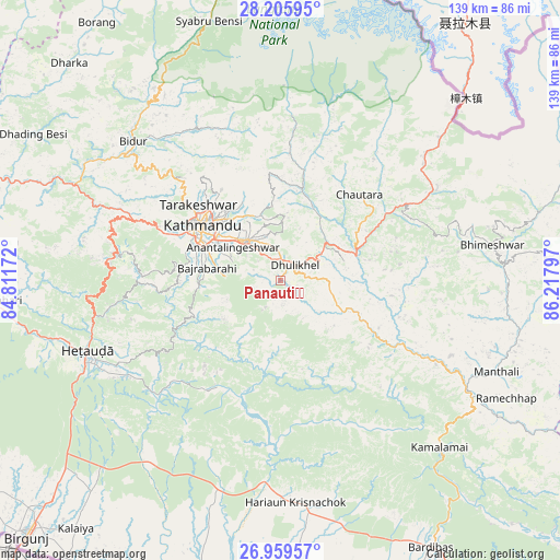
Panauti̇̄ GPS coordinates[2]
27° 35' 4.308" North, 85° 30' 53.424" East
| Map corner | latitude | longitude |
|---|---|---|
| Upper-left | 28.20595°, | 84.81172° |
| Center: | 27.58453°, | 85.51484° |
| Lower-right: | 26.95957°, | 86.21797° |
| Map W x H: | 138.6×138.6 km | = 86.1×86.1mi |
| max Lat: | 30.04651° ⇑71.6% North |
| Panauti̇̄: | 27.58453° |
| min Lat: | ⇓28.4% South 26.45505° |
| min Long | Panauti̇̄ | max Long |
| 80.17715° | 85.51484° | 88.09436° |
| W 66.2%⇐ | ⇒33.8% E |
Elevation
Elevation of Panauti̇̄ is 1455 m = 4774 ft, and this is 279.8 m = 918 ft above average elevation for this country.
| Max E: |
5251 m = 17228 ft | 28.4% |
| Panauti̇̄ | 1455 m 4774 ft | |
| Avg. | 1175.2 m = 3856 ft | |
Min E: |
72 m = 236 ft | 71.6% |
See also: Nepal elevation on elevation.city.
Geographical zone
Panauti̇̄ is located in North temperate zone (between Tropic of Cancer and the Arctic Circle). Distance of this Northern Tropic circle is 461.2 km =286.6 mi to South.| Distance of | km | miles | from Panauti̇̄ |
|---|---|---|---|
| North Pole | 6939.9 | 4312.3 | to North |
| Arctic Circle | 4334.1 | 2693.1 | to North |
| Tropic Cancer | 461.2 | 286.6 | to South |
| Equator | 3067.1 | 1905.8 | to South |


Nearby cities:
15 places around Panauti̇̄: (largest is in red/bold)
• Banepā
5.4 km =3.4 mi,  7°
7°
• Bhaktapur
12.9 km =8 mi,  319°
319°
• Chhetrapa1
60.2 km =37.4 mi,  80°
80°
• Dhulikhel
5 km =3.1 mi,  33°
33°
• Hari Bdr Tamang House
7.4 km =4.6 mi,  311°
311°
• Hetauda
50.7 km =31.5 mi,  249°
249°
• Kathmandu
23.1 km =14.4 mi,  304°
304°
• Kirtipur
25.6 km =15.9 mi,  294°
294°
• Kothari
60.3 km =37.5 mi,  46°
46°
• Madhyapur Thimi
16.5 km =10.3 mi, 310°
• Nagarkot
14.5 km =9 mi,  2°
2°
• Panauti
0.6 km =0.4 mi,  88°
88°
• Pātan
22.3 km =13.9 mi, 297°
• Rāmechhāp
63.4 km =39.4 mi,  116°
116°
• kankrabari Dovan
7.4 km =4.6 mi, 311°
Sources, notices
• [Note1] Compared only with cities in Nepal existing in our database
• [Src1] Map data: © OpenStreetMap contributors (CC-BY-SA)
• [Src2] Other city data from geonames.org with taken over terms of usage.
• [Src3] Geographical zone / Annual Mean Temperature by Robert A. Rohde @ Wikipedia
