Banepā geodata
Banepā (Central Region) is a populated place; located in Nepal in Asia/Kathmandu (GMT+5.75) time zone. With population of 17,153 people, there are 42 cities with bigger population in this country. Compared to other cities in Nepal, 64.9% of cities are located further ↑North; 70.3% of cities are located further ←West and 74.3% of cities have lower elevation than Banepā. Note1


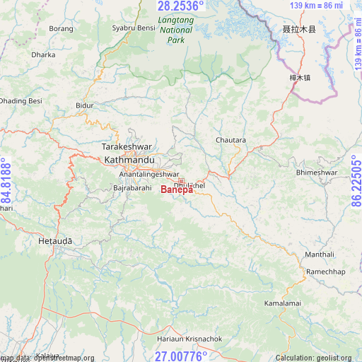
Banepā GPS coordinates[2]
27° 37' 56.82" North, 85° 31' 18.912" East
| Map corner | latitude | longitude |
|---|---|---|
| Upper-left | 28.2536°, | 84.8188° |
| Center: | 27.63245°, | 85.52192° |
| Lower-right: | 27.00776°, | 86.22505° |
| Map W x H: | 138.5×138.5 km | = 86.1×86.1mi |
| max Lat: | 30.04651° ⇑64.9% North |
| Banepā: | 27.63245° |
| min Lat: | ⇓35.1% South 26.45505° |
| min Long | Banepā | max Long |
| 80.17715° | 85.52192° | 88.09436° |
| W 70.3%⇐ | ⇒29.7% E |
Elevation
Elevation of Banepā is 1477 m = 4846 ft, and this is 301.8 m = 990 ft above average elevation for this country.
| Max E: |
5251 m = 17228 ft | 25.7% |
| Banepā | 1477 m 4846 ft | |
| Avg. | 1175.2 m = 3856 ft | |
Min E: |
72 m = 236 ft | 74.3% |
See also: Nepal elevation on elevation.city.
Geographical zone
Banepā is located in North temperate zone (between Tropic of Cancer and the Arctic Circle). Distance of this Northern Tropic circle is 466.5 km =289.9 mi to South.| Distance of | km | miles | from Banepā |
|---|---|---|---|
| North Pole | 6934.6 | 4309 | to North |
| Arctic Circle | 4328.7 | 2689.7 | to North |
| Tropic Cancer | 466.5 | 289.9 | to South |
| Equator | 3072.4 | 1909.1 | to South |


Nearby cities:
15 places around Banepā: (largest is in red/bold)
• Bhaktapur
10.1 km =6.3 mi,  296°
296°
• Chhetrapa1
58.8 km =36.5 mi,  85°
85°
• Dhulikhel
2.4 km =1.5 mi,  119°
119°
• Hari Bdr Tamang House
6.2 km =3.9 mi,  266°
266°
• Hetauda
53.4 km =33.2 mi,  244°
244°
• Kathmandu
21.3 km =13.2 mi,  291°
291°
• Kirtipur
24.6 km =15.3 mi,  282°
282°
• Kothari
56.2 km =34.9 mi,  49°
49°
• Madhyapur Thimi
14.3 km =8.9 mi, 292°
• Nagarkot
9.2 km =5.7 mi,  359°
359°
• Panauti
5.3 km =3.3 mi,  180°
180°
• Panauti̇̄
5.4 km =3.4 mi,  187°
187°
• Pātan
21 km =13 mi, 283°
• Rāmechhāp
65.4 km =40.6 mi, 121°
• kankrabari Dovan
6.2 km =3.9 mi, 266°
Sources, notices
• [Note1] Compared only with cities in Nepal existing in our database
• [Src1] Map data: © OpenStreetMap contributors (CC-BY-SA)
• [Src2] Other city data from geonames.org with taken over terms of usage.
• [Src3] Geographical zone / Annual Mean Temperature by Robert A. Rohde @ Wikipedia
