Wanaka geodata
Wanaka (Otago) is a populated place; located in New Zealand in Pacific/Auckland (GMT+12) time zone. With population of 4,428 people, there are 65 cities with bigger population in this country. Compared to other cities in New Zealand, 87% of cities are located further ↑North; 92.8% of cities are located further →East and 94.7% of cities have lower elevation than Wanaka. Note1


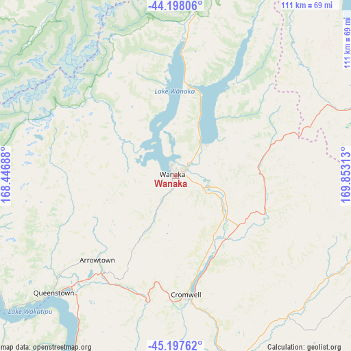
Wanaka GPS coordinates[2]
44° 42' 0" South, 169° 9' 0" East
| Map corner | latitude | longitude |
|---|---|---|
| Upper-left | -44.19806°, | 168.44688° |
| Center: | -44.7°, | 169.15° |
| Lower-right: | -45.19762°, | 169.85313° |
| Map W x H: | 111.1×111.1 km | = 69×69mi |
| max Lat: | -34.99604° ⇑87% North |
| Wanaka: | -44.7° |
| min Lat: | ⇓13% South -46.6° |
| min Long | Wanaka | max Long |
| -176.55973° | 169.15° | 178.33333° |
| W 7.2%⇐ | ⇒92.8% E |
Elevation
Elevation of Wanaka is 325 m = 1066 ft, and this is 240.6 m = 789 ft above average elevation for this country.
| Max E: |
819 m = 2687 ft | 5.3% |
| Wanaka | 325 m 1066 ft | |
| Avg. | 84.4 m = 277 ft | |
Min E: |
3 m = 10 ft | 94.7% |
See also: New Zealand elevation on elevation.city.
Geographical zone
Wanaka is located in South temperate zone (between Tropic of Capricorn and the Antarctic Circle). Distance of this Southern Tropic circle is 2364.3 km =1469.1 mi to North.| Distance of | km | miles | from Wanaka |
|---|---|---|---|
| Equator | 4970.2 | 3088.3 | to North |
| Tropic Capricorn | 2364.3 | 1469.1 | to North |
| Antarctic Circle | 2431 | 1510.6 | to South |
| South Pole | 5036.9 | 3129.8 | to South |


Nearby cities:
15 places around Wanaka: (largest is in red/bold)
• Arrowtown
37.7 km =23.4 mi,  225°
225°
• Clyde
55.6 km =34.5 mi,  166°
166°
• Cromwell
37.8 km =23.5 mi, 174°
• Fairlie
149.4 km =92.8 mi,  63°
63°
• Gore
156.8 km =97.4 mi,  185°
185°
• Kingston
78.2 km =48.6 mi,  205°
205°
• Oamaru
150.1 km =93.3 mi,  107°
107°
• Outram
155 km =96.3 mi,  146°
146°
• Pareora
163.8 km =101.8 mi,  82°
82°
• Pleasant Point
164.5 km =102.2 mi,  72°
72°
• Queenstown
53.1 km =33 mi, 226°
• Ranfurly
89 km =55.3 mi,  122°
122°
• Roxburgh
94.4 km =58.7 mi, 172°
• Te Anau
137.9 km =85.7 mi, 234°
• Waitati
161.1 km =100.1 mi,  136°
136°
Sources, notices
• [Note1] Compared only with cities in New Zealand existing in our database
• [Src1] Map data: © OpenStreetMap contributors (CC-BY-SA)
• [Src2] Other city data from geonames.org with taken over terms of usage.
• [Src3] Geographical zone / Annual Mean Temperature by Robert A. Rohde @ Wikipedia
