Wairoa geodata
Wairoa (Hawke's Bay) is a populated place; located in New Zealand in Pacific/Auckland (GMT+12) time zone. With population of 4,260 people, there are 67 cities with bigger population in this country. Compared to other cities in New Zealand, 56% of cities are located further ↓South; 97.6% of cities are located further ←West and 65.2% of cities have lower elevation than Wairoa. Note1


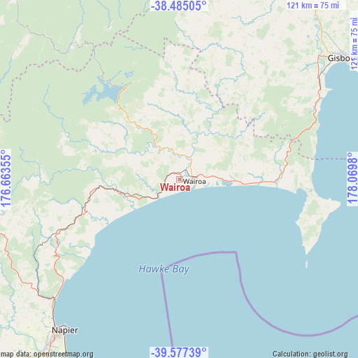
Wairoa GPS coordinates[2]
39° 1' 59.988" South, 177° 22' 0.012" East
| Map corner | latitude | longitude |
|---|---|---|
| Upper-left | -38.48505°, | 176.66355° |
| Center: | -39.03333°, | 177.36667° |
| Lower-right: | -39.57739°, | 178.0698° |
| Map W x H: | 121.5×121.5 km | = 75.5×75.5mi |
| max Lat: | -34.99604° ⇑44% North |
| Wairoa: | -39.03333° |
| min Lat: | ⇓56% South -46.6° |
| min Long | Wairoa | max Long |
| -176.55973° | 177.36667° | 178.33333° |
| W 97.6%⇐ | ⇒2.4% E |
Elevation
Elevation of Wairoa is 58 m = 190 ft, and this is 26.4 m = 87 ft below average elevation for this country.
| Max E: |
819 m = 2687 ft | 34.8% |
| Avg. | 84.4 m = 277 ft | |
| Wairoa | 58 m = 190 ft | |
Min E: |
3 m = 10 ft | 65.2% |
See also: New Zealand elevation on elevation.city.
Geographical zone
Wairoa is located in South temperate zone (between Tropic of Capricorn and the Antarctic Circle). Distance of this Southern Tropic circle is 1734.2 km =1077.6 mi to North.| Distance of | km | miles | from Wairoa |
|---|---|---|---|
| Equator | 4340.1 | 2696.8 | to North |
| Tropic Capricorn | 1734.2 | 1077.6 | to North |
| Antarctic Circle | 3061.1 | 1902.1 | to South |
| South Pole | 5667 | 3521.3 | to South |


Nearby cities:
15 places around Wairoa: (largest is in red/bold)
• Gisborne
69.5 km =43.2 mi,  52°
52°
• Hastings
80.6 km =50.1 mi,  213°
213°
• Kawerau
118.9 km =73.9 mi,  330°
330°
• Manutuke
61.5 km =38.2 mi, 50°
• Murupara
85.5 km =53.1 mi,  317°
317°
• Napier
64.3 km =40 mi,  217°
217°
• Opotiki
114.1 km =70.9 mi,  356°
356°
• Otane
113.6 km =70.6 mi, 213°
• Reporoa
111 km =69 mi,  306°
306°
• Taneatua
111.7 km =69.4 mi,  344°
344°
• Taradale
71.2 km =44.2 mi, 218°
• Taupo
117.7 km =73.1 mi,  289°
289°
• Te Karaka
76.5 km =47.5 mi,  34°
34°
• Tolaga Bay
109.8 km =68.2 mi, 47°
• Waimana
101.3 km =62.9 mi,  345°
345°
Sources, notices
• [Note1] Compared only with cities in New Zealand existing in our database
• [Src1] Map data: © OpenStreetMap contributors (CC-BY-SA)
• [Src2] Other city data from geonames.org with taken over terms of usage.
• [Src3] Geographical zone / Annual Mean Temperature by Robert A. Rohde @ Wikipedia
