Napier geodata
Napier (Hawke's Bay) is a seat of a first-order administrative division; located in New Zealand in Pacific/Auckland (GMT+13) time zone. With population of 56,787 people, there are 14 cities with bigger population in this country. Compared to other cities in New Zealand, 53.1% of cities are located further ↓South; 95.2% of cities are located further ←West and 97.1% of cities have higher elevation than Napier. Note1


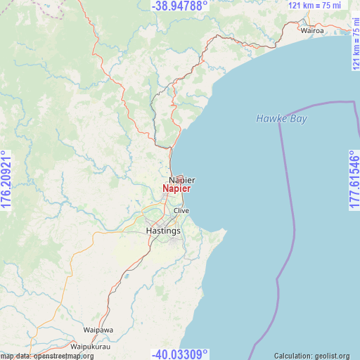
Napier GPS coordinates[2]
39° 29' 33.36" South, 176° 54' 44.388" East
| Map corner | latitude | longitude |
|---|---|---|
| Upper-left | -38.94788°, | 176.20921° |
| Center: | -39.4926°, | 176.91233° |
| Lower-right: | -40.03309°, | 177.61546° |
| Map W x H: | 120.7×120.7 km | = 75×75mi |
| max Lat: | -34.99604° ⇑46.9% North |
| Napier: | -39.4926° |
| min Lat: | ⇓53.1% South -46.6° |
| min Long | Napier | max Long |
| -176.55973° | 176.91233° | 178.33333° |
| W 95.2%⇐ | ⇒4.8% E |
Elevation
Elevation of Napier is 6 m = 20 ft, and this is 78.4 m = 257 ft below average elevation for this country.
| Max E: |
819 m = 2687 ft | 97.1% |
| Avg. | 84.4 m = 277 ft | |
| Napier | 6 m = 20 ft | |
Min E: |
3 m = 10 ft | 2.9% |
See also: Napier elevation on elevation.city.
Geographical zone
Napier is located in South temperate zone (between Tropic of Capricorn and the Antarctic Circle). Distance of this Southern Tropic circle is 1785.2 km =1109.3 mi to North.| Distance of | km | miles | from Napier |
|---|---|---|---|
| Equator | 4391.2 | 2728.6 | to North |
| Tropic Capricorn | 1785.2 | 1109.3 | to North |
| Antarctic Circle | 3010 | 1870.3 | to South |
| South Pole | 5615.9 | 3489.6 | to South |


Nearby cities:
15 places around Napier: (largest is in red/bold)
• Gisborne
132.6 km =82.4 mi,  45°
45°
• Hastings
17.1 km =10.6 mi,  198°
198°
• Hunterville
125.1 km =77.7 mi,  246°
246°
• Manutuke
124.9 km =77.6 mi,  43°
43°
• Murupara
115.5 km =71.8 mi,  350°
350°
• Otane
49.6 km =30.8 mi,  208°
208°
• Palmerston North
146.7 km =91.2 mi,  229°
229°
• Reporoa
127.4 km =79.2 mi,  337°
337°
• Takapau
77 km =47.8 mi,  218°
218°
• Taradale
7 km =4.3 mi, 229°
• Taupo
115 km =71.5 mi,  321°
321°
• Te Karaka
140.8 km =87.5 mi, 35°
• Turangi
110.3 km =68.5 mi,  300°
300°
• Waiouru
106.8 km =66.4 mi,  270°
270°
• Wairoa
64.3 km =40 mi, 37°
Sources, notices
• [Note1] Compared only with cities in New Zealand existing in our database
• [Src1] Map data: © OpenStreetMap contributors (CC-BY-SA)
• [Src2] Other city data from geonames.org with taken over terms of usage.
• [Src3] Geographical zone / Annual Mean Temperature by Robert A. Rohde @ Wikipedia
