Hastings geodata
Hastings (Hawke's Bay) is a populated place; located in New Zealand in Pacific/Auckland (GMT+13) time zone. With population of 61,696 people, there are 12 cities with bigger population in this country. Compared to other cities in New Zealand, 51.2% of cities are located further ↓South; 94.2% of cities are located further ←West and 64.3% of cities have higher elevation than Hastings. Note1


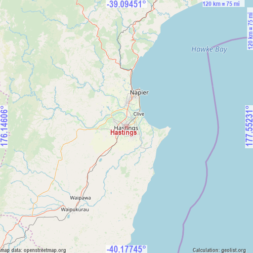
Hastings GPS coordinates[2]
39° 38' 17.16" South, 176° 50' 57.048" East
| Map corner | latitude | longitude |
|---|---|---|
| Upper-left | -39.09451°, | 176.14606° |
| Center: | -39.6381°, | 176.84918° |
| Lower-right: | -40.17745°, | 177.55231° |
| Map W x H: | 120.4×120.4 km | = 74.8×74.8mi |
| max Lat: | -34.99604° ⇑48.8% North |
| Hastings: | -39.6381° |
| min Lat: | ⇓51.2% South -46.6° |
| min Long | Hastings | max Long |
| -176.55973° | 176.84918° | 178.33333° |
| W 94.2%⇐ | ⇒5.8% E |
Elevation
Elevation of Hastings is 19 m = 62 ft, and this is 65.4 m = 215 ft below average elevation for this country.
| Max E: |
819 m = 2687 ft | 64.3% |
| Avg. | 84.4 m = 277 ft | |
| Hastings | 19 m = 62 ft | |
Min E: |
3 m = 10 ft | 35.7% |
See also: Hastings elevation on elevation.city.
Geographical zone
Hastings is located in South temperate zone (between Tropic of Capricorn and the Antarctic Circle). Distance of this Southern Tropic circle is 1801.4 km =1119.3 mi to North.| Distance of | km | miles | from Hastings |
|---|---|---|---|
| Equator | 4407.3 | 2738.6 | to North |
| Tropic Capricorn | 1801.4 | 1119.3 | to North |
| Antarctic Circle | 2993.8 | 1860.3 | to South |
| South Pole | 5599.7 | 3479.5 | to South |


Nearby cities:
15 places around Hastings: (largest is in red/bold)
• Bulls
138.4 km =86 mi,  244°
244°
• Hunterville
114.4 km =71.1 mi,  253°
253°
• Linton Military Camp
137.3 km =85.3 mi,  231°
231°
• Manutuke
140.5 km =87.3 mi,  40°
40°
• Murupara
130.9 km =81.3 mi,  354°
354°
• Napier
17.1 km =10.6 mi,  18°
18°
• Otane
32.9 km =20.4 mi,  214°
214°
• Palmerston North
132.3 km =82.2 mi, 232°
• Sanson
137.6 km =85.5 mi, 241°
• Takapau
61.2 km =38 mi,  224°
224°
• Taradale
11.6 km =7.2 mi,  0°
0°
• Taupo
125 km =77.7 mi,  328°
328°
• Turangi
114.9 km =71.4 mi,  308°
308°
• Waiouru
102.8 km =63.9 mi,  280°
280°
• Wairoa
80.6 km =50.1 mi,  33°
33°
Sources, notices
• [Note1] Compared only with cities in New Zealand existing in our database
• [Src1] Map data: © OpenStreetMap contributors (CC-BY-SA)
• [Src2] Other city data from geonames.org with taken over terms of usage.
• [Src3] Geographical zone / Annual Mean Temperature by Robert A. Rohde @ Wikipedia
