Gisborne geodata
Gisborne is a seat of a first-order administrative division; located in New Zealand in Pacific/Auckland (GMT+13) time zone. With population of 34,274 people, there are 22 cities with bigger population in this country. Compared to other cities in New Zealand, 58.5% of cities are located further ↓South; 99% of cities are located further ←West and 81.6% of cities have higher elevation than Gisborne. Note1


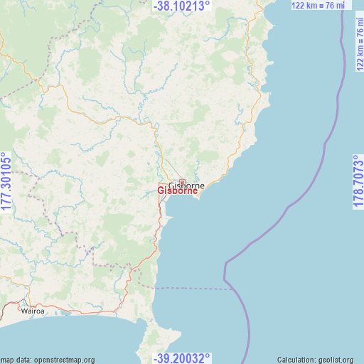
Gisborne GPS coordinates[2]
38° 39' 11.988" South, 178° 0' 15.012" East
| Map corner | latitude | longitude |
|---|---|---|
| Upper-left | -38.10213°, | 177.30105° |
| Center: | -38.65333°, | 178.00417° |
| Lower-right: | -39.20032°, | 178.7073° |
| Map W x H: | 122.1×122.1 km | = 75.9×75.9mi |
| max Lat: | -34.99604° ⇑41.5% North |
| Gisborne: | -38.65333° |
| min Lat: | ⇓58.5% South -46.6° |
| min Long | Gisborne | max Long |
| -176.55973° | 178.00417° | 178.33333° |
| W 99%⇐ | ⇒1% E |
Elevation
Elevation of Gisborne is 10 m = 33 ft, and this is 74.4 m = 244 ft below average elevation for this country.
| Max E: |
819 m = 2687 ft | 81.6% |
| Avg. | 84.4 m = 277 ft | |
| Gisborne | 10 m = 33 ft | |
Min E: |
3 m = 10 ft | 18.4% |
See also: New Zealand elevation on elevation.city.
Geographical zone
Gisborne is located in South temperate zone (between Tropic of Capricorn and the Antarctic Circle). Distance of this Southern Tropic circle is 1691.9 km =1051.3 mi to North.| Distance of | km | miles | from Gisborne |
|---|---|---|---|
| Equator | 4297.8 | 2670.5 | to North |
| Tropic Capricorn | 1691.9 | 1051.3 | to North |
| Antarctic Circle | 3103.3 | 1928.3 | to South |
| South Pole | 5709.2 | 3547.5 | to South |


Nearby cities:
15 places around Gisborne: (largest is in red/bold)
• Edgecumbe
126.4 km =78.5 mi,  306°
306°
• Kawerau
129.3 km =80.3 mi,  298°
298°
• Manutuke
8.3 km =5.2 mi,  246°
246°
• Matata
139 km =86.4 mi, 308°
• Murupara
115.3 km =71.6 mi,  280°
280°
• Napier
132.6 km =82.4 mi,  225°
225°
• Opotiki
95.1 km =59.1 mi,  318°
318°
• Ruatoria
90.3 km =56.1 mi,  18°
18°
• Taneatua
108 km =67.1 mi, 307°
• Taradale
139.6 km =86.7 mi, 225°
• Te Karaka
24 km =14.9 mi,  330°
330°
• Tolaga Bay
41 km =25.5 mi,  38°
38°
• Waimana
97.8 km =60.8 mi, 304°
• Wairoa
69.5 km =43.2 mi, 232°
• Whakatane
117.8 km =73.2 mi, 310°
Sources, notices
• [Note1] Compared only with cities in New Zealand existing in our database
• [Src1] Map data: © OpenStreetMap contributors (CC-BY-SA)
• [Src2] Other city data from geonames.org with taken over terms of usage.
• [Src3] Geographical zone / Annual Mean Temperature by Robert A. Rohde @ Wikipedia
