Veladero geodata
Veladero (Chiriquí) is a populated place; located in Panama in America/Panama (GMT-5) time zone. With population of 530 people, there are 462 cities with bigger population in this country. Compared to other cities in Panama, 54.7% of cities are located further ↑North; 90.7% of cities are located further →East and 56.3% of cities have higher elevation than Veladero. Note1


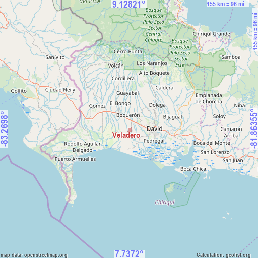
Veladero GPS coordinates[2]
8° 25' 59.988" North, 82° 34' 0.012" West
| Map corner | latitude | longitude |
|---|---|---|
| Upper-left | 9.12821°, | -83.2698° |
| Center: | 8.43333°, | -82.56667° |
| Lower-right: | 7.7372°, | -81.86355° |
| Map W x H: | 154.7×154.7 km | = 96.1×96.1mi |
| max Lat: | 9.60898° ⇑54.7% North |
| Veladero: | 8.43333° |
| min Lat: | ⇓45.3% South 7.26534° |
| min Long | Veladero | max Long |
| -82.91275° | -82.56667° | -77.38965° |
| W 9.3%⇐ | ⇒90.7% E |
Elevation
Elevation of Veladero is 61 m = 200 ft, and this is 111.1 m = 365 ft below average elevation for this country.
| Max E: |
2103 m = 6900 ft | 56.3% |
| Avg. | 172.1 m = 565 ft | |
| Veladero | 61 m = 200 ft | |
Min E: |
-1 m = -3 ft | 43.7% |
See also: Panama elevation on elevation.city.
Geographical zone
Veladero is located in North Torrid zone (between Equator and Tropic of Cancer). Distance of Equator is 937.7 km =582.7 mi to South.| Distance of | km | miles | from Veladero |
|---|---|---|---|
| North Pole | 9069.4 | 5635.5 | to North |
| Arctic Circle | 6463.5 | 4016.2 | to North |
| Tropic Cancer | 1668.2 | 1036.6 | to North |
| Equator | 937.7 | 582.7 | to South |


Nearby cities:
15 places around Veladero: (largest is in red/bold)
• Alanje
4 km =2.5 mi,  168°
168°
• Boquerón
8 km =5 mi,  357°
357°
• Bugaba
8 km =5 mi,  313°
313°
• Bágala
5.6 km =3.5 mi,  52°
52°
• Chacarero
7.1 km =4.4 mi,  330°
330°
• El Tejar
0.8 km =0.5 mi,  239°
239°
• Loma de San Pedro
1.8 km =1.1 mi,  117°
117°
• Montilla
10.2 km =6.3 mi,  70°
70°
• Orillas del Río
10.3 km =6.4 mi,  141°
141°
• Querévalo
8.1 km =5 mi,  147°
147°
• San Juan del Tejal
10.2 km =6.3 mi, 54°
• San Pablo Nuevo Abajo
7.2 km =4.5 mi,  96°
96°
• San Pablo Viejo Abajo
7.5 km =4.7 mi, 72°
• San Pablo Viejo Arriba
8.6 km =5.3 mi, 52°
• Tijeras
4.7 km =2.9 mi,  8°
8°
Sources, notices
• [Note1] Compared only with cities in Panama existing in our database
• [Src1] Map data: © OpenStreetMap contributors (CC-BY-SA)
• [Src2] Other city data from geonames.org with taken over terms of usage.
• [Src3] Geographical zone / Annual Mean Temperature by Robert A. Rohde @ Wikipedia
