Loma de San Pedro geodata
Loma de San Pedro (Chiriquí) is a populated place; located in Panama in America/Panama (GMT-5) time zone. With population of 719 people, there are 347 cities with bigger population in this country. Compared to other cities in Panama, 55.5% of cities are located further ↑North; 90.2% of cities are located further →East and 58.6% of cities have higher elevation than Loma de San Pedro. Note1


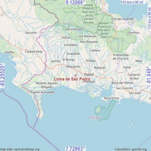
Loma de San Pedro GPS coordinates[2]
8° 25' 32.772" North, 82° 33' 7.632" West
| Map corner | latitude | longitude |
|---|---|---|
| Upper-left | 9.12066°, | -83.25525° |
| Center: | 8.42577°, | -82.55212° |
| Lower-right: | 7.72963°, | -81.849° |
| Map W x H: | 154.7×154.7 km | = 96.1×96.1mi |
| max Lat: | 9.60898° ⇑55.5% North |
| Loma de San Pedro: | 8.42577° |
| min Lat: | ⇓44.5% South 7.26534° |
| min Long | Loma de San Ped | max Long |
| -82.91275° | -82.55212° | -77.38965° |
| W 9.8%⇐ | ⇒90.2% E |
Elevation
Elevation of Loma de San Pedro is 57 m = 187 ft, and this is 115.1 m = 378 ft below average elevation for this country.
| Max E: |
2103 m = 6900 ft | 58.6% |
| Avg. | 172.1 m = 565 ft | |
| Loma de San Pedro | 57 m = 187 ft | |
Min E: |
-1 m = -3 ft | 41.4% |
See also: Panama elevation on elevation.city.
Geographical zone
Loma de San Pedro is located in North Torrid zone (between Equator and Tropic of Cancer). Distance of Equator is 936.9 km =582.2 mi to South.| Distance of | km | miles | from Loma de San Pedro |
|---|---|---|---|
| North Pole | 9070.2 | 5636 | to North |
| Arctic Circle | 6464.3 | 4016.7 | to North |
| Tropic Cancer | 1669.1 | 1037.1 | to North |
| Equator | 936.9 | 582.2 | to South |


Nearby cities:
15 places around Loma de San Pedro: (largest is in red/bold)
• Alanje
3.2 km =2 mi,  194°
194°
• Boquerón
9 km =5.6 mi,  347°
347°
• Bágala
5.1 km =3.2 mi,  33°
33°
• Chacarero
8.7 km =5.4 mi,  324°
324°
• El Tejar
2.3 km =1.4 mi,  280°
280°
• Guarumal
9.2 km =5.7 mi,  166°
166°
• Montilla
9.1 km =5.7 mi,  62°
62°
• Orillas del Río
8.7 km =5.4 mi,  145°
145°
• Querévalo
6.6 km =4.1 mi,  155°
155°
• San Juan del Tejal
9.6 km =6 mi,  44°
44°
• San Pablo Nuevo Abajo
5.5 km =3.4 mi,  90°
90°
• San Pablo Viejo Abajo
6.3 km =3.9 mi, 60°
• San Pablo Viejo Arriba
8 km =5 mi, 40°
• Tijeras
5.6 km =3.5 mi, 350°
• Veladero
1.8 km =1.1 mi,  297°
297°
Sources, notices
• [Note1] Compared only with cities in Panama existing in our database
• [Src1] Map data: © OpenStreetMap contributors (CC-BY-SA)
• [Src2] Other city data from geonames.org with taken over terms of usage.
• [Src3] Geographical zone / Annual Mean Temperature by Robert A. Rohde @ Wikipedia
