Santa Isabel geodata
Santa Isabel (Colón) is a seat of a third-order administrative division; located in Panama in America/Panama (GMT-5) time zone. With population of 256 people, there are 570 cities with bigger population in this country. Compared to other cities in Panama, 98.6% of cities are located further ↓South; 90.9% of cities are located further ←West and 97.4% of cities have higher elevation than Santa Isabel. Note1


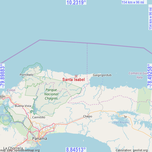
Santa Isabel GPS coordinates[2]
9° 32' 21.192" North, 79° 11' 44.52" West
| Map corner | latitude | longitude |
|---|---|---|
| Upper-left | 10.2319°, | -79.89883° |
| Center: | 9.53922°, | -79.1957° |
| Lower-right: | 8.84513°, | -78.49258° |
| Map W x H: | 154.2×154.2 km | = 95.8×95.8mi |
| max Lat: | 9.60898° ⇑1.4% North |
| Santa Isabel: | 9.53922° |
| min Lat: | ⇓98.6% South 7.26534° |
| min Long | Santa Isabel | max Long |
| -82.91275° | -79.1957° | -77.38965° |
| W 90.9%⇐ | ⇒9.1% E |
Elevation
Elevation of Santa Isabel is 5 m = 16 ft, and this is 167.1 m = 548 ft below average elevation for this country.
| Max E: |
2103 m = 6900 ft | 97.4% |
| Avg. | 172.1 m = 565 ft | |
| Santa Isabel | 5 m = 16 ft | |
Min E: |
-1 m = -3 ft | 2.6% |
See also: Panama elevation on elevation.city.
Geographical zone
Santa Isabel is located in North Torrid zone (between Equator and Tropic of Cancer). Distance of Equator is 1060.7 km =659.1 mi to South.| Distance of | km | miles | from Santa Isabel |
|---|---|---|---|
| North Pole | 8946.4 | 5559 | to North |
| Arctic Circle | 6340.5 | 3939.8 | to North |
| Tropic Cancer | 1545.3 | 960.2 | to North |
| Equator | 1060.7 | 659.1 | to South |


Nearby cities:
15 places around Santa Isabel: (largest is in red/bold)
• Cartí Sugdup
27.2 km =16.9 mi,  107°
107°
• Cuango
13.6 km =8.5 mi,  282°
282°
• El Porvenir
26.7 km =16.6 mi,  86°
86°
• El Progreso
31.5 km =19.6 mi,  164°
164°
• Juan Gil
40.7 km =25.3 mi,  189°
189°
• La Mesa
41.6 km =25.8 mi, 191°
• Las Margaritas
41.2 km =25.6 mi, 163°
• Miramar
15.9 km =9.9 mi, 284°
• Nombre de Dios
30.5 km =19 mi, 278°
• Palenque
18.7 km =11.6 mi, 280°
• Palmira
2.7 km =1.7 mi, 280°
• Playa Chiquita
11 km =6.8 mi,  285°
285°
• San Miguel
36.6 km =22.7 mi, 190°
• Tubualá
18 km =11.2 mi,  98°
98°
• Viento Frío
23.7 km =14.7 mi, 281°
Sources, notices
• [Note1] Compared only with cities in Panama existing in our database
• [Src1] Map data: © OpenStreetMap contributors (CC-BY-SA)
• [Src2] Other city data from geonames.org with taken over terms of usage.
• [Src3] Geographical zone / Annual Mean Temperature by Robert A. Rohde @ Wikipedia
