El Porvenir geodata
El Porvenir (Guna Yala) is a seat of a first-order administrative division; located in Panama in America/Panama (GMT-5) time zone. With population of 10 people, there are 693 cities with bigger population in this country. Compared to other cities in Panama, 99% of cities are located further ↓South; 92.1% of cities are located further ←West and 99.5% of cities have higher elevation than El Porvenir. Note1


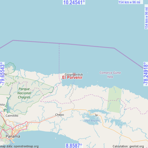
El Porvenir GPS coordinates[2]
9° 33' 9.936" North, 78° 57' 8.28" West
| Map corner | latitude | longitude |
|---|---|---|
| Upper-left | 10.24541°, | -79.65543° |
| Center: | 9.55276°, | -78.9523° |
| Lower-right: | 8.8587°, | -78.24918° |
| Map W x H: | 154.2×154.2 km | = 95.8×95.8mi |
| max Lat: | 9.60898° ⇑1% North |
| El Porvenir: | 9.55276° |
| min Lat: | ⇓99% South 7.26534° |
| min Long | El Porvenir | max Long |
| -82.91275° | -78.9523° | -77.38965° |
| W 92.1%⇐ | ⇒7.9% E |
Elevation
Elevation of El Porvenir is 2 m = 7 ft, and this is 170.1 m = 558 ft below average elevation for this country.
| Max E: |
2103 m = 6900 ft | 99.5% |
| Avg. | 172.1 m = 565 ft | |
| El Porvenir | 2 m = 7 ft | |
Min E: |
-1 m = -3 ft | 0.5% |
See also: Panama elevation on elevation.city.
Geographical zone
El Porvenir is located in North Torrid zone (between Equator and Tropic of Cancer). Distance of Equator is 1062.2 km =660 mi to South.| Distance of | km | miles | from El Porvenir |
|---|---|---|---|
| North Pole | 8944.9 | 5558.1 | to North |
| Arctic Circle | 6339 | 3938.9 | to North |
| Tropic Cancer | 1543.8 | 959.3 | to North |
| Equator | 1062.2 | 660 | to South |


Nearby cities:
15 places around El Porvenir: (largest is in red/bold)
• Cartí Sugdup
9.8 km =6.1 mi,  184°
184°
• Cañita
37.3 km =23.2 mi,  170°
170°
• Chepo
45.6 km =28.3 mi,  200°
200°
• Cuango
40 km =24.9 mi,  272°
272°
• El Progreso
36.6 km =22.7 mi,  209°
209°
• Icantí
47.8 km =29.7 mi,  141°
141°
• Isla Tigre
49.2 km =30.6 mi,  106°
106°
• Las Margaritas
43.6 km =27.1 mi, 199°
• Miramar
42.1 km =26.2 mi, 273°
• Narganá
41.9 km =26 mi, 106°
• Palenque
45.1 km =28 mi, 272°
• Palmira
29.3 km =18.2 mi, 268°
• Playa Chiquita
37.3 km =23.2 mi, 272°
• Santa Isabel
26.7 km =16.6 mi, 266°
• Tubualá
9.7 km =6 mi,  245°
245°
Sources, notices
• [Note1] Compared only with cities in Panama existing in our database
• [Src1] Map data: © OpenStreetMap contributors (CC-BY-SA)
• [Src2] Other city data from geonames.org with taken over terms of usage.
• [Src3] Geographical zone / Annual Mean Temperature by Robert A. Rohde @ Wikipedia
