Quinteño geodata
Quinteño (Chiriquí) is a populated place; located in Panama in America/Panama (GMT-5) time zone. With population of 1,324 people, there are 184 cities with bigger population in this country. Compared to other cities in Panama, 50.1% of cities are located further ↓South; 83.9% of cities are located further →East and 59.8% of cities have lower elevation than Quinteño. Note1


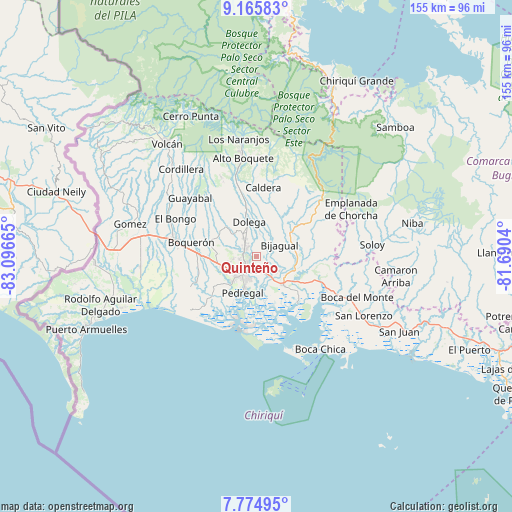
Quinteño GPS coordinates[2]
8° 28' 15.672" North, 82° 23' 36.672" West
| Map corner | latitude | longitude |
|---|---|---|
| Upper-left | 9.16583°, | -83.09665° |
| Center: | 8.47102°, | -82.39352° |
| Lower-right: | 7.77495°, | -81.6904° |
| Map W x H: | 154.7×154.7 km | = 96.1×96.1mi |
| max Lat: | 9.60898° ⇑49.9% North |
| Quinteño: | 8.47102° |
| min Lat: | ⇓50.1% South 7.26534° |
| min Long | Quinteño | max Long |
| -82.91275° | -82.39352° | -77.38965° |
| W 16.1%⇐ | ⇒83.9% E |
Elevation
Elevation of Quinteño is 104 m = 341 ft, and this is 68.1 m = 223 ft below average elevation for this country.
| Max E: |
2103 m = 6900 ft | 40.2% |
| Avg. | 172.1 m = 565 ft | |
| Quinteño | 104 m = 341 ft | |
Min E: |
-1 m = -3 ft | 59.8% |
See also: Panama elevation on elevation.city.
Geographical zone
Quinteño is located in North Torrid zone (between Equator and Tropic of Cancer). Distance of Equator is 941.9 km =585.3 mi to South.| Distance of | km | miles | from Quinteño |
|---|---|---|---|
| North Pole | 9065.2 | 5632.9 | to North |
| Arctic Circle | 6459.3 | 4013.6 | to North |
| Tropic Cancer | 1664 | 1034 | to North |
| Equator | 941.9 | 585.3 | to South |


Nearby cities:
15 places around Quinteño: (largest is in red/bold)
• Aguacatal
6.9 km =4.3 mi,  260°
260°
• Algarrobos Arriba
5.9 km =3.7 mi,  327°
327°
• Angostura de Cochea Arriba
7.5 km =4.7 mi,  15°
15°
• Cochea Abajo
5.4 km =3.4 mi,  45°
45°
• David
6.4 km =4 mi,  220°
220°
• Dos Ríos Abajo
6.4 km =4 mi,  6°
6°
• Guayabal
4.1 km =2.5 mi,  104°
104°
• Las Lomas
4.7 km =2.9 mi,  171°
171°
• Los Algarrobos
4.4 km =2.7 mi,  309°
309°
• Los Anastacios
7.3 km =4.5 mi, 333°
• Mata del Nance
2.4 km =1.5 mi,  198°
198°
• Nuevo San Carlitos
5 km =3.1 mi,  251°
251°
• Portachuelo
2.8 km =1.7 mi,  274°
274°
• Rincón Largo
5.7 km =3.5 mi,  345°
345°
• San Carlitos
6.5 km =4 mi,  283°
283°
Sources, notices
• [Note1] Compared only with cities in Panama existing in our database
• [Src1] Map data: © OpenStreetMap contributors (CC-BY-SA)
• [Src2] Other city data from geonames.org with taken over terms of usage.
• [Src3] Geographical zone / Annual Mean Temperature by Robert A. Rohde @ Wikipedia
