Las Guabas geodata
Las Guabas (Los Santos) is a seat of a third-order administrative division; located in Panama in America/Panama (GMT-5) time zone. With population of 192 people, there are 605 cities with bigger population in this country. Compared to other cities in Panama, 89.2% of cities are located further ↑North; 53.3% of cities are located further ←West and 50.1% of cities have higher elevation than Las Guabas. Note1


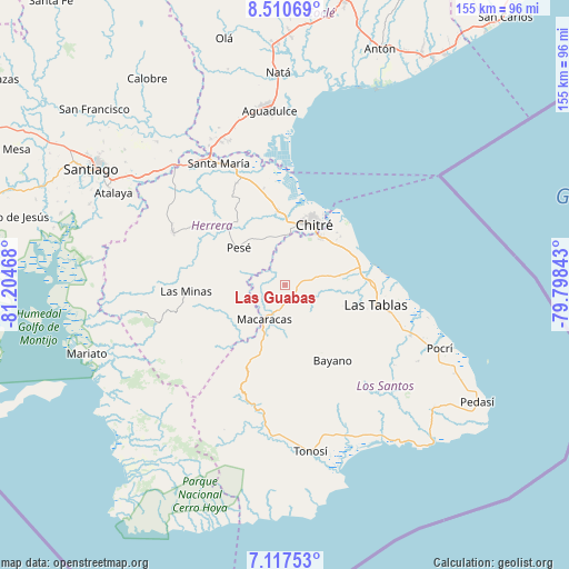
Las Guabas GPS coordinates[2]
7° 48' 52.884" North, 80° 30' 5.58" West
| Map corner | latitude | longitude |
|---|---|---|
| Upper-left | 8.51069°, | -81.20468° |
| Center: | 7.81469°, | -80.50155° |
| Lower-right: | 7.11753°, | -79.79843° |
| Map W x H: | 154.9×154.9 km | = 96.3×96.3mi |
| max Lat: | 9.60898° ⇑89.2% North |
| Las Guabas: | 7.81469° |
| min Lat: | ⇓10.8% South 7.26534° |
| min Long | Las Guabas | max Long |
| -82.91275° | -80.50155° | -77.38965° |
| W 53.3%⇐ | ⇒46.7% E |
Elevation
Elevation of Las Guabas is 72 m = 236 ft, and this is 100.1 m = 328 ft below average elevation for this country.
| Max E: |
2103 m = 6900 ft | 50.1% |
| Avg. | 172.1 m = 565 ft | |
| Las Guabas | 72 m = 236 ft | |
Min E: |
-1 m = -3 ft | 49.9% |
See also: Panama elevation on elevation.city.
Geographical zone
Las Guabas is located in North Torrid zone (between Equator and Tropic of Cancer). Distance of Equator is 868.9 km =539.9 mi to South.| Distance of | km | miles | from Las Guabas |
|---|---|---|---|
| North Pole | 9138.1 | 5678.2 | to North |
| Arctic Circle | 6532.3 | 4059 | to North |
| Tropic Cancer | 1737 | 1079.3 | to North |
| Equator | 868.9 | 539.9 | to South |


Nearby cities:
15 places around Las Guabas: (largest is in red/bold)
• Agua Buena
12 km =7.5 mi,  79°
79°
• Cedro Arriba
4.9 km =3 mi,  220°
220°
• Chupá
8.2 km =5.1 mi,  258°
258°
• El Guásimo
3.3 km =2.1 mi,  253°
253°
• La Arena
12.3 km =7.6 mi,  234°
234°
• La Colorada
6 km =3.7 mi,  279°
279°
• Las Cabras
8.6 km =5.3 mi,  322°
322°
• Las Cruces
7.9 km =4.9 mi, 83°
• Llano Abajo
10.5 km =6.5 mi,  107°
107°
• Los Cerritos
12.2 km =7.6 mi, 260°
• Los Olivos
11.3 km =7 mi,  7°
7°
• Macaracas
10.9 km =6.8 mi,  211°
211°
• Rincón Hondo
11.8 km =7.3 mi,  286°
286°
• Tres Quebradas
10.8 km =6.7 mi,  74°
74°
• Villa Lourdes
3.5 km =2.2 mi,  96°
96°
Sources, notices
• [Note1] Compared only with cities in Panama existing in our database
• [Src1] Map data: © OpenStreetMap contributors (CC-BY-SA)
• [Src2] Other city data from geonames.org with taken over terms of usage.
• [Src3] Geographical zone / Annual Mean Temperature by Robert A. Rohde @ Wikipedia
