El Pedregoso geodata
El Pedregoso (Herrera) is a seat of a third-order administrative division; located in Panama in America/Panama (GMT-5) time zone. With population of 452 people, there are 499 cities with bigger population in this country. Compared to other cities in Panama, 85% of cities are located further ↑North; 52.5% of cities are located further →East and 50.4% of cities have higher elevation than El Pedregoso. Note1


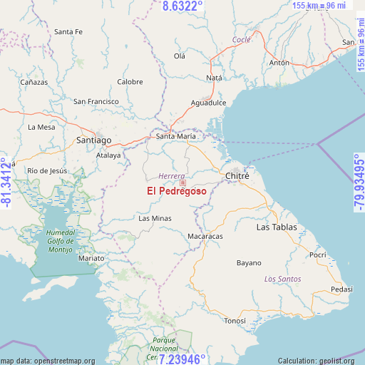
El Pedregoso GPS coordinates[2]
7° 56' 11.112" North, 80° 38' 17.052" West
| Map corner | latitude | longitude |
|---|---|---|
| Upper-left | 8.6322°, | -81.3412° |
| Center: | 7.93642°, | -80.63807° |
| Lower-right: | 7.23946°, | -79.93495° |
| Map W x H: | 154.9×154.9 km | = 96.3×96.3mi |
| max Lat: | 9.60898° ⇑85% North |
| El Pedregoso: | 7.93642° |
| min Lat: | ⇓15% South 7.26534° |
| min Long | El Pedregoso | max Long |
| -82.91275° | -80.63807° | -77.38965° |
| W 47.5%⇐ | ⇒52.5% E |
Elevation
Elevation of El Pedregoso is 71 m = 233 ft, and this is 101.1 m = 332 ft below average elevation for this country.
| Max E: |
2103 m = 6900 ft | 50.4% |
| Avg. | 172.1 m = 565 ft | |
| El Pedregoso | 71 m = 233 ft | |
Min E: |
-1 m = -3 ft | 49.6% |
See also: Panama elevation on elevation.city.
Geographical zone
El Pedregoso is located in North Torrid zone (between Equator and Tropic of Cancer). Distance of Equator is 882.4 km =548.3 mi to South.| Distance of | km | miles | from El Pedregoso |
|---|---|---|---|
| North Pole | 9124.6 | 5669.8 | to North |
| Arctic Circle | 6518.7 | 4050.5 | to North |
| Tropic Cancer | 1723.5 | 1070.9 | to North |
| Equator | 882.4 | 548.3 | to South |


Nearby cities:
15 places around El Pedregoso: (largest is in red/bold)
• Cabuya
10.6 km =6.6 mi,  3°
3°
• Chumical
14.1 km =8.8 mi,  223°
223°
• El Barrero
13.7 km =8.5 mi,  91°
91°
• El Pájaro
7.5 km =4.7 mi,  84°
84°
• La Trinidad
7.6 km =4.7 mi,  251°
251°
• Las Cabras
11.9 km =7.4 mi,  124°
124°
• Llano Grande
9.1 km =5.7 mi,  297°
297°
• Llano de La Cruz
1.8 km =1.1 mi,  344°
344°
• Los Castillos
5.9 km =3.7 mi,  21°
21°
• Los Hatillos
11 km =6.8 mi, 93°
• Pesé
4 km =2.5 mi,  139°
139°
• Portobelillo
10.2 km =6.3 mi,  27°
27°
• Potuga
14.2 km =8.8 mi,  6°
6°
• Rincón Hondo
10.9 km =6.8 mi,  159°
159°
• Sabana Grande
6.3 km =3.9 mi,  180°
180°
Sources, notices
• [Note1] Compared only with cities in Panama existing in our database
• [Src1] Map data: © OpenStreetMap contributors (CC-BY-SA)
• [Src2] Other city data from geonames.org with taken over terms of usage.
• [Src3] Geographical zone / Annual Mean Temperature by Robert A. Rohde @ Wikipedia
