Los Hatillos geodata
Los Hatillos (Herrera) is a populated place; located in Panama in America/Panama (GMT-5) time zone. With population of 687 people, there are 365 cities with bigger population in this country. Compared to other cities in Panama, 85.5% of cities are located further ↑North; 52.1% of cities are located further ←West and 56.8% of cities have higher elevation than Los Hatillos. Note1


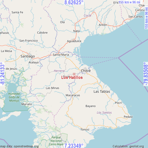
Los Hatillos GPS coordinates[2]
7° 55' 49.656" North, 80° 32' 17.52" West
| Map corner | latitude | longitude |
|---|---|---|
| Upper-left | 8.62625°, | -81.24133° |
| Center: | 7.93046°, | -80.5382° |
| Lower-right: | 7.23349°, | -79.83508° |
| Map W x H: | 154.9×154.9 km | = 96.3×96.3mi |
| max Lat: | 9.60898° ⇑85.5% North |
| Los Hatillos: | 7.93046° |
| min Lat: | ⇓14.5% South 7.26534° |
| min Long | Los Hatillos | max Long |
| -82.91275° | -80.5382° | -77.38965° |
| W 52.1%⇐ | ⇒47.9% E |
Elevation
Elevation of Los Hatillos is 60 m = 197 ft, and this is 112.1 m = 368 ft below average elevation for this country.
| Max E: |
2103 m = 6900 ft | 56.8% |
| Avg. | 172.1 m = 565 ft | |
| Los Hatillos | 60 m = 197 ft | |
Min E: |
-1 m = -3 ft | 43.2% |
See also: Panama elevation on elevation.city.
Geographical zone
Los Hatillos is located in North Torrid zone (between Equator and Tropic of Cancer). Distance of Equator is 881.8 km =547.9 mi to South.| Distance of | km | miles | from Los Hatillos |
|---|---|---|---|
| North Pole | 9125.3 | 5670.2 | to North |
| Arctic Circle | 6519.4 | 4051 | to North |
| Tropic Cancer | 1724.1 | 1071.3 | to North |
| Equator | 881.8 | 547.9 | to South |


Nearby cities:
15 places around Los Hatillos: (largest is in red/bold)
• Chitré
12.4 km =7.7 mi,  74°
74°
• El Barrero
2.7 km =1.7 mi,  83°
83°
• El Pedregoso
11 km =6.8 mi,  273°
273°
• El Pájaro
3.8 km =2.4 mi,  292°
292°
• La Arena
9 km =5.6 mi,  62°
62°
• La Colorada
12 km =7.5 mi,  189°
189°
• Las Cabras
6.2 km =3.9 mi, 191°
• Llano de La Cruz
11.7 km =7.3 mi,  281°
281°
• Los Castillos
10.8 km =6.7 mi,  304°
304°
• Los Olivos
5.7 km =3.5 mi,  106°
106°
• Parita
7.3 km =4.5 mi,  15°
15°
• Pesé
8.7 km =5.4 mi,  253°
253°
• Portobelillo
11.5 km =7.1 mi,  326°
326°
• Rincón Hondo
12 km =7.5 mi,  217°
217°
• Sabana Grande
12.4 km =7.7 mi,  243°
243°
Sources, notices
• [Note1] Compared only with cities in Panama existing in our database
• [Src1] Map data: © OpenStreetMap contributors (CC-BY-SA)
• [Src2] Other city data from geonames.org with taken over terms of usage.
• [Src3] Geographical zone / Annual Mean Temperature by Robert A. Rohde @ Wikipedia
