Pesé geodata
Pesé (Herrera) is a seat of a second-order administrative division; located in Panama in America/Panama (GMT-5) time zone. With population of 2,565 people, there are 100 cities with bigger population in this country. Compared to other cities in Panama, 86.3% of cities are located further ↑North; 51% of cities are located further →East and 54.4% of cities have lower elevation than Pesé. Note1


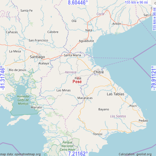
Pesé GPS coordinates[2]
7° 54' 31.068" North, 80° 36' 51.588" West
| Map corner | latitude | longitude |
|---|---|---|
| Upper-left | 8.60446°, | -81.31746° |
| Center: | 7.90863°, | -80.61433° |
| Lower-right: | 7.21162°, | -79.91121° |
| Map W x H: | 154.9×154.9 km | = 96.3×96.3mi |
| max Lat: | 9.60898° ⇑86.3% North |
| Pesé: | 7.90863° |
| min Lat: | ⇓13.7% South 7.26534° |
| min Long | Pesé | max Long |
| -82.91275° | -80.61433° | -77.38965° |
| W 49%⇐ | ⇒51% E |
Elevation
Elevation of Pesé is 85 m = 279 ft, and this is 87.1 m = 286 ft below average elevation for this country.
| Max E: |
2103 m = 6900 ft | 45.6% |
| Avg. | 172.1 m = 565 ft | |
| Pesé | 85 m = 279 ft | |
Min E: |
-1 m = -3 ft | 54.4% |
See also: Panama elevation on elevation.city.
Geographical zone
Pesé is located in North Torrid zone (between Equator and Tropic of Cancer). Distance of Equator is 879.4 km =546.4 mi to South.| Distance of | km | miles | from Pesé |
|---|---|---|---|
| North Pole | 9127.7 | 5671.7 | to North |
| Arctic Circle | 6521.8 | 4052.5 | to North |
| Tropic Cancer | 1726.6 | 1072.9 | to North |
| Equator | 879.4 | 546.4 | to South |


Nearby cities:
15 places around Pesé: (largest is in red/bold)
• Chupá
12.9 km =8 mi,  160°
160°
• El Barrero
11.4 km =7.1 mi,  76°
76°
• El Pedregoso
4 km =2.5 mi,  319°
319°
• El Pájaro
6.2 km =3.9 mi,  51°
51°
• La Colorada
11.5 km =7.1 mi,  145°
145°
• La Trinidad
9.8 km =6.1 mi,  273°
273°
• Las Cabras
8.1 km =5 mi,  117°
117°
• Llano Grande
12.9 km =8 mi,  304°
304°
• Llano de La Cruz
5.7 km =3.5 mi,  327°
327°
• Los Castillos
8.6 km =5.3 mi,  356°
356°
• Los Cerritos
12.4 km =7.7 mi,  178°
178°
• Los Hatillos
8.7 km =5.4 mi,  73°
73°
• Portobelillo
12.3 km =7.6 mi,  9°
9°
• Rincón Hondo
7.2 km =4.5 mi,  170°
170°
• Sabana Grande
4.1 km =2.5 mi,  219°
219°
Sources, notices
• [Note1] Compared only with cities in Panama existing in our database
• [Src1] Map data: © OpenStreetMap contributors (CC-BY-SA)
• [Src2] Other city data from geonames.org with taken over terms of usage.
• [Src3] Geographical zone / Annual Mean Temperature by Robert A. Rohde @ Wikipedia
