Las Cabras geodata
Las Cabras (Herrera) is a seat of a third-order administrative division; located in Panama in America/Panama (GMT-5) time zone. In our database, there are 694 cities with bigger population. Compared to other cities in Panama, 87.5% of cities are located further ↑North; 51.6% of cities are located further ←West and 59.7% of cities have higher elevation than Las Cabras. Note1


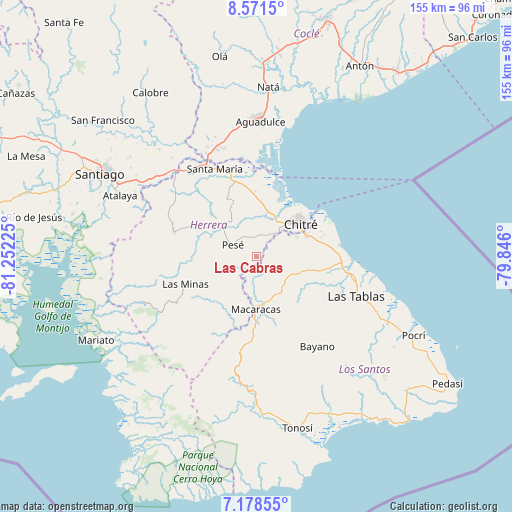
Las Cabras GPS coordinates[2]
7° 52' 32.196" North, 80° 32' 56.832" West
| Map corner | latitude | longitude |
|---|---|---|
| Upper-left | 8.5715°, | -81.25225° |
| Center: | 7.87561°, | -80.54912° |
| Lower-right: | 7.17855°, | -79.846° |
| Map W x H: | 154.9×154.9 km | = 96.3×96.3mi |
| max Lat: | 9.60898° ⇑87.5% North |
| Las Cabras: | 7.87561° |
| min Lat: | ⇓12.5% South 7.26534° |
| min Long | Las Cabras | max Long |
| -82.91275° | -80.54912° | -77.38965° |
| W 51.6%⇐ | ⇒48.4% E |
Elevation
Elevation of Las Cabras is 53 m = 174 ft, and this is 119.1 m = 391 ft below average elevation for this country.
| Max E: |
2103 m = 6900 ft | 59.7% |
| Avg. | 172.1 m = 565 ft | |
| Las Cabras | 53 m = 174 ft | |
Min E: |
-1 m = -3 ft | 40.3% |
See also: Panama elevation on elevation.city.
Geographical zone
Las Cabras is located in North Torrid zone (between Equator and Tropic of Cancer). Distance of Equator is 875.7 km =544.1 mi to South.| Distance of | km | miles | from Las Cabras |
|---|---|---|---|
| North Pole | 9131.4 | 5674 | to North |
| Arctic Circle | 6525.5 | 4054.8 | to North |
| Tropic Cancer | 1730.2 | 1075.1 | to North |
| Equator | 875.7 | 544.1 | to South |


Nearby cities:
15 places around Las Cabras: (largest is in red/bold)
• Cedro Arriba
10.7 km =6.6 mi,  169°
169°
• Chupá
8.9 km =5.5 mi,  198°
198°
• El Barrero
7.5 km =4.7 mi,  31°
31°
• El Guásimo
8 km =5 mi,  164°
164°
• El Pedregoso
11.9 km =7.4 mi,  304°
304°
• El Pájaro
7.9 km =4.9 mi,  342°
342°
• La Colorada
5.8 km =3.6 mi,  186°
186°
• Las Guabas
8.6 km =5.3 mi,  142°
142°
• Los Cerritos
11 km =6.8 mi,  217°
217°
• Los Hatillos
6.2 km =3.9 mi,  11°
11°
• Los Olivos
8 km =5 mi,  55°
55°
• Pesé
8.1 km =5 mi, 297°
• Rincón Hondo
7 km =4.3 mi,  240°
240°
• Sabana Grande
9.8 km =6.1 mi,  272°
272°
• Villa Lourdes
11.2 km =7 mi,  129°
129°
Sources, notices
• [Note1] Compared only with cities in Panama existing in our database
• [Src1] Map data: © OpenStreetMap contributors (CC-BY-SA)
• [Src2] Other city data from geonames.org with taken over terms of usage.
• [Src3] Geographical zone / Annual Mean Temperature by Robert A. Rohde @ Wikipedia
