Pocrí geodata
Pocrí (Coclé) is a seat of a third-order administrative division; located in Panama in America/Panama (GMT-5) time zone. With population of 12,304 people, there are 32 cities with bigger population in this country. Compared to other cities in Panama, 68.9% of cities are located further ↑North; 51.5% of cities are located further ←West and 75.7% of cities have higher elevation than Pocrí. Note1


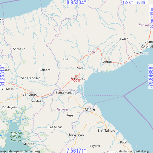
Pocrí GPS coordinates[2]
8° 15' 29.304" North, 80° 33' 0" West
| Map corner | latitude | longitude |
|---|---|---|
| Upper-left | 8.95334°, | -81.25313° |
| Center: | 8.25814°, | -80.55° |
| Lower-right: | 7.56171°, | -79.84688° |
| Map W x H: | 154.7×154.7 km | = 96.1×96.1mi |
| max Lat: | 9.60898° ⇑68.9% North |
| Pocrí: | 8.25814° |
| min Lat: | ⇓31.1% South 7.26534° |
| min Long | Pocrí | max Long |
| -82.91275° | -80.55° | -77.38965° |
| W 51.5%⇐ | ⇒48.5% E |
Elevation
Elevation of Pocrí is 29 m = 95 ft, and this is 143.1 m = 469 ft below average elevation for this country.
| Max E: |
2103 m = 6900 ft | 75.7% |
| Avg. | 172.1 m = 565 ft | |
| Pocrí | 29 m = 95 ft | |
Min E: |
-1 m = -3 ft | 24.3% |
See also: Panama elevation on elevation.city.
Geographical zone
Pocrí is located in North Torrid zone (between Equator and Tropic of Cancer). Distance of Equator is 918.2 km =570.5 mi to South.| Distance of | km | miles | from Pocrí |
|---|---|---|---|
| North Pole | 9088.8 | 5647.5 | to North |
| Arctic Circle | 6483 | 4028.3 | to North |
| Tropic Cancer | 1687.7 | 1048.7 | to North |
| Equator | 918.2 | 570.5 | to South |


Nearby cities:
15 places around Pocrí: (largest is in red/bold)
• Aguadulce
1.9 km =1.2 mi,  166°
166°
• Barranco Colorado
17.4 km =10.8 mi,  327°
327°
• Capellanía
4.5 km =2.8 mi,  353°
353°
• Churubé Abajo
15.7 km =9.8 mi,  3°
3°
• El Caño
16.4 km =10.2 mi,  12°
12°
• El Cortezo
10.5 km =6.5 mi,  337°
337°
• El Cristo
7.8 km =4.8 mi,  263°
263°
• El Rincón
17.1 km =10.6 mi,  205°
205°
• El Roble
15.6 km =9.7 mi,  230°
230°
• La Loma
14 km =8.7 mi,  223°
223°
• Las Guabas
18.2 km =11.3 mi,  38°
38°
• Llano Sánchez
18.2 km =11.3 mi,  248°
248°
• Natá
8.9 km =5.5 mi,  22°
22°
• Salitrosa
11.1 km =6.9 mi,  241°
241°
• Toza
13.9 km =8.6 mi,  314°
314°
Sources, notices
• [Note1] Compared only with cities in Panama existing in our database
• [Src1] Map data: © OpenStreetMap contributors (CC-BY-SA)
• [Src2] Other city data from geonames.org with taken over terms of usage.
• [Src3] Geographical zone / Annual Mean Temperature by Robert A. Rohde @ Wikipedia
