Aguadulce geodata
Aguadulce (Coclé) is a seat of a second-order administrative division; located in Panama in America/Panama (GMT-5) time zone. With population of 8,501 people, there are 48 cities with bigger population in this country. Compared to other cities in Panama, 70.2% of cities are located further ↑North; 51.9% of cities are located further ←West and 77% of cities have higher elevation than Aguadulce. Note1


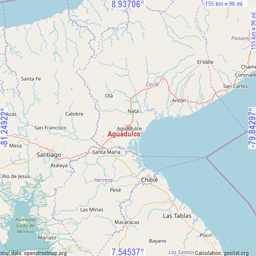
Aguadulce GPS coordinates[2]
8° 14' 30.588" North, 80° 32' 45.924" West
| Map corner | latitude | longitude |
|---|---|---|
| Upper-left | 8.93706°, | -81.24922° |
| Center: | 8.24183°, | -80.54609° |
| Lower-right: | 7.54537°, | -79.84297° |
| Map W x H: | 154.7×154.7 km | = 96.1×96.1mi |
| max Lat: | 9.60898° ⇑70.2% North |
| Aguadulce: | 8.24183° |
| min Lat: | ⇓29.8% South 7.26534° |
| min Long | Aguadulce | max Long |
| -82.91275° | -80.54609° | -77.38965° |
| W 51.9%⇐ | ⇒48.1% E |
Elevation
Elevation of Aguadulce is 28 m = 92 ft, and this is 144.1 m = 473 ft below average elevation for this country.
| Max E: |
2103 m = 6900 ft | 77% |
| Avg. | 172.1 m = 565 ft | |
| Aguadulce | 28 m = 92 ft | |
Min E: |
-1 m = -3 ft | 23% |
See also: Panama elevation on elevation.city.
Geographical zone
Aguadulce is located in North Torrid zone (between Equator and Tropic of Cancer). Distance of Equator is 916.4 km =569.4 mi to South.| Distance of | km | miles | from Aguadulce |
|---|---|---|---|
| North Pole | 9090.7 | 5648.7 | to North |
| Arctic Circle | 6484.8 | 4029.5 | to North |
| Tropic Cancer | 1689.5 | 1049.8 | to North |
| Equator | 916.4 | 569.4 | to South |


Nearby cities:
15 places around Aguadulce: (largest is in red/bold)
• Barranco Colorado
19.1 km =11.9 mi,  329°
329°
• Capellanía
6.4 km =4 mi,  351°
351°
• Churubé Abajo
17.5 km =10.9 mi,  1°
1°
• El Barrero
18.7 km =11.6 mi,  239°
239°
• El Caño
18.1 km =11.2 mi,  9°
9°
• El Cortezo
12.4 km =7.7 mi,  338°
338°
• El Cristo
8.3 km =5.2 mi,  276°
276°
• El Rincón
15.7 km =9.8 mi,  209°
209°
• El Roble
14.9 km =9.3 mi, 236°
• La Loma
13.1 km =8.1 mi,  230°
230°
• Llano Sánchez
18.1 km =11.2 mi,  254°
254°
• Natá
10.4 km =6.5 mi,  16°
16°
• Pocrí
1.9 km =1.2 mi, 346°
• Salitrosa
10.7 km =6.6 mi, 251°
• Toza
15.5 km =9.6 mi,  318°
318°
Sources, notices
• [Note1] Compared only with cities in Panama existing in our database
• [Src1] Map data: © OpenStreetMap contributors (CC-BY-SA)
• [Src2] Other city data from geonames.org with taken over terms of usage.
• [Src3] Geographical zone / Annual Mean Temperature by Robert A. Rohde @ Wikipedia
