El Roble geodata
El Roble (Coclé) is a seat of a third-order administrative division; located in Panama in America/Panama (GMT-5) time zone. With population of 1,648 people, there are 146 cities with bigger population in this country. Compared to other cities in Panama, 73.4% of cities are located further ↑North; 53.5% of cities are located further →East and 72.4% of cities have higher elevation than El Roble. Note1


El Roble GPS coordinates[2]
8° 10' 6.6" North, 80° 39' 32.292" West
| Map corner | latitude | longitude |
|---|---|---|
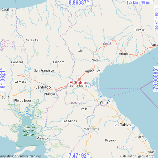
| Upper-left | 8.86387°, | -81.3621° |
| Center: | 8.1685°, | -80.65897° |
| Lower-right: | 7.47192°, | -79.95585° |
| Map W x H: | 154.8×154.8 km | = 96.2×96.2mi |
| max Lat: | 9.60898° ⇑73.4% North |
| El Roble: | 8.1685° |
| min Lat: | ⇓26.6% South 7.26534° |
| min Long | El Roble | max Long |
| -82.91275° | -80.65897° | -77.38965° |
| W 46.5%⇐ | ⇒53.5% E |
Elevation
Elevation of El Roble is 33 m = 108 ft, and this is 139.1 m = 456 ft below average elevation for this country.
| Max E: |
2103 m = 6900 ft | 72.4% |
| Avg. | 172.1 m = 565 ft | |
| El Roble | 33 m = 108 ft | |
Min E: |
-1 m = -3 ft | 27.6% |
See also: Panama elevation on elevation.city.
Geographical zone
El Roble is located in North Torrid zone (between Equator and Tropic of Cancer). Distance of Equator is 908.3 km =564.4 mi to South.| Distance of | km | miles | from El Roble |
|---|---|---|---|
| North Pole | 9098.8 | 5653.7 | to North |
| Arctic Circle | 6492.9 | 4034.5 | to North |
| Tropic Cancer | 1697.7 | 1054.9 | to North |
| Equator | 908.3 | 564.4 | to South |


Nearby cities:
15 places around El Roble: (largest is in red/bold)
• Aguadulce
14.9 km =9.3 mi,  56°
56°
• Cabuya
15.5 km =9.6 mi,  169°
169°
• Cañazas
7 km =4.3 mi,  246°
246°
• El Barrero
4 km =2.5 mi, 248°
• El Cristo
10.1 km =6.3 mi,  24°
24°
• El Pedernal
13.9 km =8.6 mi,  257°
257°
• El Rincón
7.2 km =4.5 mi,  139°
139°
• La Loma
2.4 km =1.5 mi,  94°
94°
• Las Guías Abajo
11 km =6.8 mi,  285°
285°
• Llano Sánchez
6.1 km =3.8 mi,  303°
303°
• Los Canelos
7.8 km =4.8 mi,  223°
223°
• Pocrí
15.6 km =9.7 mi,  50°
50°
• Potuga
12.4 km =7.7 mi,  161°
161°
• Salitrosa
5.2 km =3.2 mi,  25°
25°
• Santa María
6.4 km =4 mi,  186°
186°
Sources, notices
• [Note1] Compared only with cities in Panama existing in our database
• [Src1] Map data: © OpenStreetMap contributors (CC-BY-SA)
• [Src2] Other city data from geonames.org with taken over terms of usage.
• [Src3] Geographical zone / Annual Mean Temperature by Robert A. Rohde @ Wikipedia
