Monte Lirio geodata
Monte Lirio (Chiriquí) is a seat of a third-order administrative division; located in Panama in America/Panama (GMT-5) time zone. With population of 715 people, there are 348 cities with bigger population in this country. Compared to other cities in Panama, 73.2% of cities are located further ↓South; 97.9% of cities are located further →East and 96.2% of cities have lower elevation than Monte Lirio. Note1


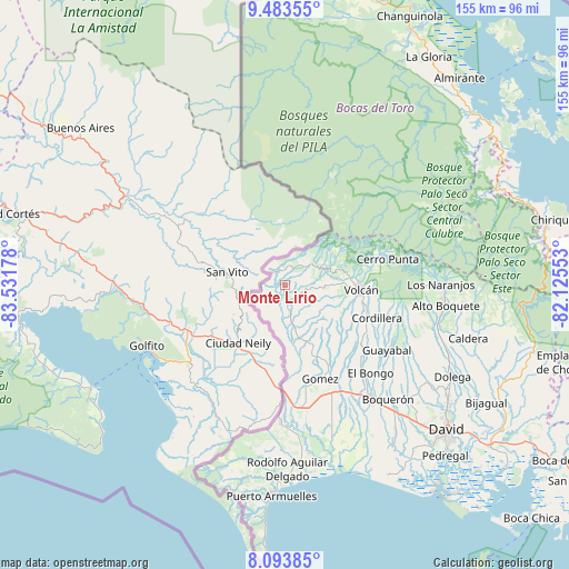
Monte Lirio GPS coordinates[2]
8° 47' 21.66" North, 82° 49' 43.14" West
| Map corner | latitude | longitude |
|---|---|---|
| Upper-left | 9.48355°, | -83.53178° |
| Center: | 8.78935°, | -82.82865° |
| Lower-right: | 8.09385°, | -82.12553° |
| Map W x H: | 154.5×154.5 km | = 96×96mi |
| max Lat: | 9.60898° ⇑26.8% North |
| Monte Lirio: | 8.78935° |
| min Lat: | ⇓73.2% South 7.26534° |
| min Long | Monte Lirio | max Long |
| -82.91275° | -82.82865° | -77.38965° |
| W 2.1%⇐ | ⇒97.9% E |
Elevation
Elevation of Monte Lirio is 834 m = 2736 ft, and this is 661.9 m = 2172 ft above average elevation for this country.
| Max E: |
2103 m = 6900 ft | 3.8% |
| Monte Lirio | 834 m 2736 ft | |
| Avg. | 172.1 m = 565 ft | |
Min E: |
-1 m = -3 ft | 96.2% |
See also: Panama elevation on elevation.city.
Geographical zone
Monte Lirio is located in North Torrid zone (between Equator and Tropic of Cancer). Distance of Equator is 977.3 km =607.3 mi to South.| Distance of | km | miles | from Monte Lirio |
|---|---|---|---|
| North Pole | 9029.8 | 5610.9 | to North |
| Arctic Circle | 6423.9 | 3991.6 | to North |
| Tropic Cancer | 1628.6 | 1012 | to North |
| Equator | 977.3 | 607.3 | to South |


Nearby cities:
15 places around Monte Lirio: (largest is in red/bold)
• Alto Quiel
10.2 km =6.3 mi,  229°
229°
• Breñón
18.4 km =11.4 mi,  174°
174°
• Cañas Gordas
10.6 km =6.6 mi,  240°
240°
• La Bonita
20.2 km =12.6 mi,  159°
159°
• Miraflores
6.1 km =3.8 mi,  0°
0°
• Palmarito
3.2 km =2 mi,  7°
7°
• Paso Canoas Arriba
24.9 km =15.5 mi,  178°
178°
• Piedra Candela
13.1 km =8.1 mi,  38°
38°
• Plaza de Caisán
5.9 km =3.7 mi, 170°
• Río Sereno
4.4 km =2.7 mi,  314°
314°
• San Andrés
23.6 km =14.7 mi,  151°
151°
• San Francisco
20.5 km =12.7 mi, 147°
• Santa Clara
7.3 km =4.5 mi,  47°
47°
• Santa Cruz
18 km =11.2 mi, 154°
• Volcán
21 km =13 mi,  94°
94°
Sources, notices
• [Note1] Compared only with cities in Panama existing in our database
• [Src1] Map data: © OpenStreetMap contributors (CC-BY-SA)
• [Src2] Other city data from geonames.org with taken over terms of usage.
• [Src3] Geographical zone / Annual Mean Temperature by Robert A. Rohde @ Wikipedia
