Volcán geodata
Volcán (Chiriquí) is a seat of a third-order administrative division; located in Panama in America/Panama (GMT-5) time zone. With population of 10,286 people, there are 39 cities with bigger population in this country. Compared to other cities in Panama, 72.4% of cities are located further ↓South; 92.8% of cities are located further →East and 99.5% of cities have lower elevation than Volcán. Note1


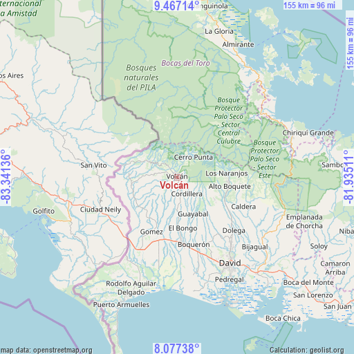
Volcán GPS coordinates[2]
8° 46' 22.476" North, 82° 38' 17.628" West
| Map corner | latitude | longitude |
|---|---|---|
| Upper-left | 9.46714°, | -83.34136° |
| Center: | 8.77291°, | -82.63823° |
| Lower-right: | 8.07738°, | -81.93511° |
| Map W x H: | 154.5×154.5 km | = 96×96mi |
| max Lat: | 9.60898° ⇑27.6% North |
| Volcán: | 8.77291° |
| min Lat: | ⇓72.4% South 7.26534° |
| min Long | Volcán | max Long |
| -82.91275° | -82.63823° | -77.38965° |
| W 7.2%⇐ | ⇒92.8% E |
Elevation
Elevation of Volcán is 1394 m = 4573 ft, and this is 1221.9 m = 4009 ft above average elevation for this country.
| Max E: |
2103 m = 6900 ft | 0.5% |
| Volcán | 1394 m 4573 ft | |
| Avg. | 172.1 m = 565 ft | |
Min E: |
-1 m = -3 ft | 99.5% |
See also: Panama elevation on elevation.city.
Geographical zone
Volcán is located in North Torrid zone (between Equator and Tropic of Cancer). Distance of Equator is 975.5 km =606.1 mi to South.| Distance of | km | miles | from Volcán |
|---|---|---|---|
| North Pole | 9031.6 | 5612 | to North |
| Arctic Circle | 6425.7 | 3992.7 | to North |
| Tropic Cancer | 1630.5 | 1013.1 | to North |
| Equator | 975.5 | 606.1 | to South |


Nearby cities:
15 places around Volcán: (largest is in red/bold)
• Alto Quiel
18.4 km =11.4 mi,  78°
78°
• Barrio Guadalupe
13 km =8.1 mi,  38°
38°
• Cerro Punta
11.2 km =7 mi, 40°
• Cordillera
8.3 km =5.2 mi,  152°
152°
• El Banco
16.5 km =10.3 mi,  123°
123°
• Guayabal
18 km =11.2 mi,  158°
158°
• Palmira
20.2 km =12.6 mi,  102°
102°
• Paraíso
14 km =8.7 mi, 155°
• Piedra Candela
17.5 km =10.9 mi,  313°
313°
• Potrerillos Arriba
18.9 km =11.7 mi, 120°
• San Francisco
18.4 km =11.4 mi,  212°
212°
• San Vicente
20.3 km =12.6 mi,  179°
179°
• Santa Clara
16.9 km =10.5 mi,  293°
293°
• Santa Cruz
19.7 km =12.2 mi,  222°
222°
• Santa Rosa
19.9 km =12.4 mi,  194°
194°
Sources, notices
• [Note1] Compared only with cities in Panama existing in our database
• [Src1] Map data: © OpenStreetMap contributors (CC-BY-SA)
• [Src2] Other city data from geonames.org with taken over terms of usage.
• [Src3] Geographical zone / Annual Mean Temperature by Robert A. Rohde @ Wikipedia
