Divalá geodata
Divalá (Chiriquí) is a seat of a third-order administrative division; located in Panama in America/Panama (GMT-5) time zone. With population of 2,506 people, there are 102 cities with bigger population in this country. Compared to other cities in Panama, 56.7% of cities are located further ↑North; 94.5% of cities are located further →East and 82.5% of cities have higher elevation than Divalá. Note1


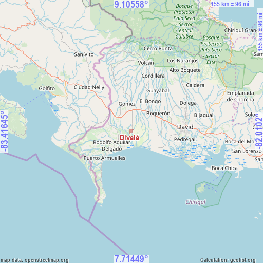
Divalá GPS coordinates[2]
8° 24' 38.376" North, 82° 42' 47.952" West
| Map corner | latitude | longitude |
|---|---|---|
| Upper-left | 9.10558°, | -83.41645° |
| Center: | 8.41066°, | -82.71332° |
| Lower-right: | 7.71449°, | -82.0102° |
| Map W x H: | 154.7×154.7 km | = 96.1×96.1mi |
| max Lat: | 9.60898° ⇑56.7% North |
| Divalá: | 8.41066° |
| min Lat: | ⇓43.3% South 7.26534° |
| min Long | Divalá | max Long |
| -82.91275° | -82.71332° | -77.38965° |
| W 5.5%⇐ | ⇒94.5% E |
Elevation
Elevation of Divalá is 20 m = 66 ft, and this is 152.1 m = 499 ft below average elevation for this country.
| Max E: |
2103 m = 6900 ft | 82.5% |
| Avg. | 172.1 m = 565 ft | |
| Divalá | 20 m = 66 ft | |
Min E: |
-1 m = -3 ft | 17.5% |
See also: Panama elevation on elevation.city.
Geographical zone
Divalá is located in North Torrid zone (between Equator and Tropic of Cancer). Distance of Equator is 935.2 km =581.1 mi to South.| Distance of | km | miles | from Divalá |
|---|---|---|---|
| North Pole | 9071.9 | 5637 | to North |
| Arctic Circle | 6466 | 4017.8 | to North |
| Tropic Cancer | 1670.7 | 1038.1 | to North |
| Equator | 935.2 | 581.1 | to South |


Nearby cities:
15 places around Divalá: (largest is in red/bold)
• Aserrío de Gariché
11.7 km =7.3 mi,  313°
313°
• Berba
11.4 km =7.1 mi,  255°
255°
• Bugaba
13 km =8.1 mi,  52°
52°
• El Roble
12.4 km =7.7 mi,  327°
327°
• Gariché
11.2 km =7 mi,  316°
316°
• La Esperanza
8.7 km =5.4 mi, 264°
• La Estrella
12.5 km =7.8 mi,  21°
21°
• Majagual
10 km =6.2 mi,  216°
216°
• Manaca Norte
13.6 km =8.5 mi,  231°
231°
• Palo Grande
13.8 km =8.6 mi,  121°
121°
• San Valentín
8.7 km =5.4 mi,  236°
236°
• Santa Marta
11.6 km =7.2 mi,  7°
7°
• Santo Domingo
10.8 km =6.7 mi,  0°
0°
• Santo Tomás
7.3 km =4.5 mi,  108°
108°
• Sioguí Abajo
10 km =6.2 mi,  31°
31°
Sources, notices
• [Note1] Compared only with cities in Panama existing in our database
• [Src1] Map data: © OpenStreetMap contributors (CC-BY-SA)
• [Src2] Other city data from geonames.org with taken over terms of usage.
• [Src3] Geographical zone / Annual Mean Temperature by Robert A. Rohde @ Wikipedia
