Santo Tomás geodata
Santo Tomás (Chiriquí) is a seat of a third-order administrative division; located in Panama in America/Panama (GMT-5) time zone. With population of 653 people, there are 379 cities with bigger population in this country. Compared to other cities in Panama, 58.4% of cities are located further ↑North; 92.9% of cities are located further →East and 81.5% of cities have higher elevation than Santo Tomás. Note1


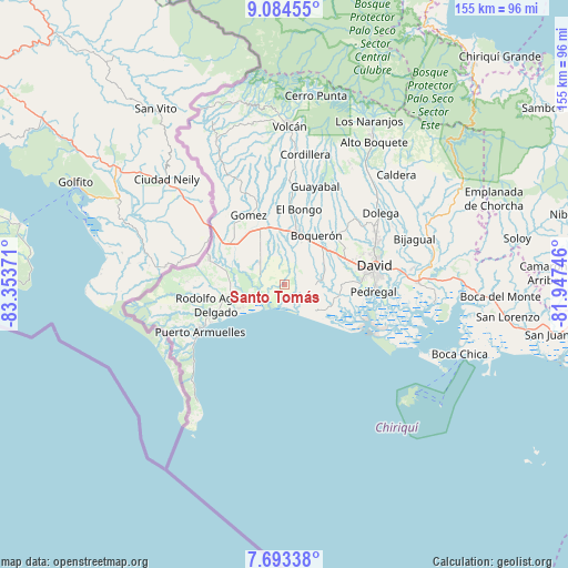
Santo Tomás GPS coordinates[2]
8° 23' 22.524" North, 82° 39' 2.088" West
| Map corner | latitude | longitude |
|---|---|---|
| Upper-left | 9.08455°, | -83.35371° |
| Center: | 8.38959°, | -82.65058° |
| Lower-right: | 7.69338°, | -81.94746° |
| Map W x H: | 154.7×154.7 km | = 96.1×96.1mi |
| max Lat: | 9.60898° ⇑58.4% North |
| Santo Tomás: | 8.38959° |
| min Lat: | ⇓41.6% South 7.26534° |
| min Long | Santo Tomás | max Long |
| -82.91275° | -82.65058° | -77.38965° |
| W 7.1%⇐ | ⇒92.9% E |
Elevation
Elevation of Santo Tomás is 21 m = 69 ft, and this is 151.1 m = 496 ft below average elevation for this country.
| Max E: |
2103 m = 6900 ft | 81.5% |
| Avg. | 172.1 m = 565 ft | |
| Santo Tomás | 21 m = 69 ft | |
Min E: |
-1 m = -3 ft | 18.5% |
See also: Panama elevation on elevation.city.
Geographical zone
Santo Tomás is located in North Torrid zone (between Equator and Tropic of Cancer). Distance of Equator is 932.8 km =579.6 mi to South.| Distance of | km | miles | from Santo Tomás |
|---|---|---|---|
| North Pole | 9074.2 | 5638.4 | to North |
| Arctic Circle | 6468.3 | 4019.2 | to North |
| Tropic Cancer | 1673.1 | 1039.6 | to North |
| Equator | 932.8 | 579.6 | to South |


Nearby cities:
15 places around Santo Tomás: (largest is in red/bold)
• Alanje
10.1 km =6.3 mi,  84°
84°
• Bugaba
10.9 km =6.8 mi,  18°
18°
• Chacarero
12.5 km =7.8 mi,  27°
27°
• Divalá
7.3 km =4.5 mi,  288°
288°
• El Tejar
9.6 km =6 mi,  62°
62°
• Guarumal
13.9 km =8.6 mi,  110°
110°
• La Concepción
14.1 km =8.8 mi,  14°
14°
• La Estrella
14.2 km =8.8 mi,  350°
350°
• Loma de San Pedro
11.6 km =7.2 mi,  69°
69°
• Majagual
14.1 km =8.8 mi,  246°
246°
• Palo Grande
6.9 km =4.3 mi,  134°
134°
• Querévalo
13.8 km =8.6 mi,  98°
98°
• Sioguí Abajo
10.9 km =6.8 mi, 351°
• Tijeras
13.7 km =8.5 mi,  46°
46°
• Veladero
10.4 km =6.5 mi, 62°
Sources, notices
• [Note1] Compared only with cities in Panama existing in our database
• [Src1] Map data: © OpenStreetMap contributors (CC-BY-SA)
• [Src2] Other city data from geonames.org with taken over terms of usage.
• [Src3] Geographical zone / Annual Mean Temperature by Robert A. Rohde @ Wikipedia
