Limones geodata
Limones (Chiriquí) is a seat of a third-order administrative division; located in Panama in America/Panama (GMT-5) time zone. With population of 315 people, there are 553 cities with bigger population in this country. Compared to other cities in Panama, 76.8% of cities are located further ↑North; 99% of cities are located further →East and 60.2% of cities have higher elevation than Limones. Note1


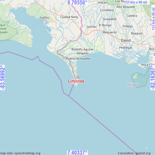
Limones GPS coordinates[2]
8° 6' 0.252" North, 82° 52' 0.444" West
| Map corner | latitude | longitude |
|---|---|---|
| Upper-left | 8.79556°, | -83.56992° |
| Center: | 8.10007°, | -82.86679° |
| Lower-right: | 7.40337°, | -82.16367° |
| Map W x H: | 154.8×154.8 km | = 96.2×96.2mi |
| max Lat: | 9.60898° ⇑76.8% North |
| Limones: | 8.10007° |
| min Lat: | ⇓23.2% South 7.26534° |
| min Long | Limones | max Long |
| -82.91275° | -82.86679° | -77.38965° |
| W 1%⇐ | ⇒99% E |
Elevation
Elevation of Limones is 52 m = 171 ft, and this is 120.1 m = 394 ft below average elevation for this country.
| Max E: |
2103 m = 6900 ft | 60.2% |
| Avg. | 172.1 m = 565 ft | |
| Limones | 52 m = 171 ft | |
Min E: |
-1 m = -3 ft | 39.8% |
See also: Panama elevation on elevation.city.
Geographical zone
Limones is located in North Torrid zone (between Equator and Tropic of Cancer). Distance of Equator is 900.6 km =559.6 mi to South.| Distance of | km | miles | from Limones |
|---|---|---|---|
| North Pole | 9106.4 | 5658.5 | to North |
| Arctic Circle | 6500.5 | 4039.2 | to North |
| Tropic Cancer | 1705.3 | 1059.6 | to North |
| Equator | 900.6 | 559.6 | to South |


Nearby cities:
15 places around Limones: (largest is in red/bold)
• Agua Buena
22.2 km =13.8 mi,  358°
358°
• Berba
32.2 km =20 mi,  10°
10°
• El Palmar
22.4 km =13.9 mi,  3°
3°
• Finca Balsa
36.7 km =22.8 mi,  354°
354°
• Finca Blanco
31.1 km =19.3 mi, 358°
• Finca Corredor
27 km =16.8 mi, 358°
• La Esperanza
34.7 km =21.6 mi, 13°
• Majagual
28.7 km =17.8 mi,  22°
22°
• Manaca Civil
25.6 km =15.9 mi, 12°
• Manaca Norte
26.8 km =16.7 mi, 13°
• Monte Verde
19.4 km =12.1 mi, 358°
• Puerto Armuelles
19.8 km =12.3 mi, 1°
• Punta de Burica
7.4 km =4.6 mi,  179°
179°
• San Bartolo Línea
23.9 km =14.9 mi, 356°
• San Valentín
31.2 km =19.4 mi, 17°
Sources, notices
• [Note1] Compared only with cities in Panama existing in our database
• [Src1] Map data: © OpenStreetMap contributors (CC-BY-SA)
• [Src2] Other city data from geonames.org with taken over terms of usage.
• [Src3] Geographical zone / Annual Mean Temperature by Robert A. Rohde @ Wikipedia
