Las Cruces geodata
Las Cruces (Los Santos) is a seat of a third-order administrative division; located in Panama in America/Panama (GMT-5) time zone. With population of 823 people, there are 309 cities with bigger population in this country. Compared to other cities in Panama, 88.8% of cities are located further ↑North; 55.8% of cities are located further ←West and 53.3% of cities have higher elevation than Las Cruces. Note1


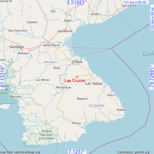
Las Cruces GPS coordinates[2]
7° 49' 22.26" North, 80° 25' 48.108" West
| Map corner | latitude | longitude |
|---|---|---|
| Upper-left | 8.51883°, | -81.13316° |
| Center: | 7.82285°, | -80.43003° |
| Lower-right: | 7.1257°, | -79.72691° |
| Map W x H: | 154.9×154.9 km | = 96.3×96.3mi |
| max Lat: | 9.60898° ⇑88.8% North |
| Las Cruces: | 7.82285° |
| min Lat: | ⇓11.2% South 7.26534° |
| min Long | Las Cruces | max Long |
| -82.91275° | -80.43003° | -77.38965° |
| W 55.8%⇐ | ⇒44.2% E |
Elevation
Elevation of Las Cruces is 65 m = 213 ft, and this is 107.1 m = 351 ft below average elevation for this country.
| Max E: |
2103 m = 6900 ft | 53.3% |
| Avg. | 172.1 m = 565 ft | |
| Las Cruces | 65 m = 213 ft | |
Min E: |
-1 m = -3 ft | 46.7% |
See also: Panama elevation on elevation.city.
Geographical zone
Las Cruces is located in North Torrid zone (between Equator and Tropic of Cancer). Distance of Equator is 869.8 km =540.5 mi to South.| Distance of | km | miles | from Las Cruces |
|---|---|---|---|
| North Pole | 9137.2 | 5677.6 | to North |
| Arctic Circle | 6531.4 | 4058.4 | to North |
| Tropic Cancer | 1736.1 | 1078.8 | to North |
| Equator | 869.8 | 540.5 | to South |


Nearby cities:
15 places around Las Cruces: (largest is in red/bold)
• Agua Buena
4.2 km =2.6 mi,  71°
71°
• Cedro Arriba
12 km =7.5 mi,  247°
247°
• El Ejido
11.4 km =7.1 mi,  24°
24°
• El Guásimo
11.2 km =7 mi,  260°
260°
• El Hato
6.2 km =3.9 mi,  122°
122°
• Guararé Arriba
8.1 km =5 mi,  108°
108°
• La Espigadilla
8.1 km =5 mi,  32°
32°
• Las Guabas
7.9 km =4.9 mi, 263°
• Las Trancas
11.7 km =7.3 mi,  147°
147°
• Llano Abajo
4.6 km =2.9 mi, 152°
• Llano Largo
9.3 km =5.8 mi,  3°
3°
• Los Ángeles
10.5 km =6.5 mi,  49°
49°
• Sabana Grande
7.3 km =4.5 mi,  78°
78°
• Tres Quebradas
3.2 km =2 mi, 52°
• Villa Lourdes
4.6 km =2.9 mi, 253°
Sources, notices
• [Note1] Compared only with cities in Panama existing in our database
• [Src1] Map data: © OpenStreetMap contributors (CC-BY-SA)
• [Src2] Other city data from geonames.org with taken over terms of usage.
• [Src3] Geographical zone / Annual Mean Temperature by Robert A. Rohde @ Wikipedia
