El Ejido geodata
El Ejido (Los Santos) is a populated place; located in Panama in America/Panama (GMT-5) time zone. With population of 1,120 people, there are 219 cities with bigger population in this country. Compared to other cities in Panama, 85.8% of cities are located further ↑North; 58.2% of cities are located further ←West and 67.4% of cities have higher elevation than El Ejido. Note1


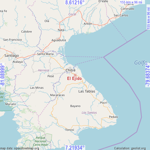
El Ejido GPS coordinates[2]
7° 54' 58.824" North, 80° 23' 12.696" West
| Map corner | latitude | longitude |
|---|---|---|
| Upper-left | 8.61216°, | -81.08999° |
| Center: | 7.91634°, | -80.38686° |
| Lower-right: | 7.21934°, | -79.68374° |
| Map W x H: | 154.9×154.9 km | = 96.3×96.3mi |
| max Lat: | 9.60898° ⇑85.8% North |
| El Ejido: | 7.91634° |
| min Lat: | ⇓14.2% South 7.26534° |
| min Long | El Ejido | max Long |
| -82.91275° | -80.38686° | -77.38965° |
| W 58.2%⇐ | ⇒41.8% E |
Elevation
Elevation of El Ejido is 39 m = 128 ft, and this is 133.1 m = 437 ft below average elevation for this country.
| Max E: |
2103 m = 6900 ft | 67.4% |
| Avg. | 172.1 m = 565 ft | |
| El Ejido | 39 m = 128 ft | |
Min E: |
-1 m = -3 ft | 32.6% |
See also: Panama elevation on elevation.city.
Geographical zone
El Ejido is located in North Torrid zone (between Equator and Tropic of Cancer). Distance of Equator is 880.2 km =546.9 mi to South.| Distance of | km | miles | from El Ejido |
|---|---|---|---|
| North Pole | 9126.8 | 5671.1 | to North |
| Arctic Circle | 6521 | 4052 | to North |
| Tropic Cancer | 1725.7 | 1072.3 | to North |
| Equator | 880.2 | 546.9 | to South |


Nearby cities:
15 places around El Ejido: (largest is in red/bold)
• Agua Buena
9.1 km =5.7 mi,  184°
184°
• Chitré
6.8 km =4.2 mi,  316°
316°
• El Espinal
9.3 km =5.8 mi,  126°
126°
• La Arena
10.3 km =6.4 mi,  303°
303°
• La Espigadilla
3.6 km =2.2 mi,  186°
186°
• Llano Bonito
7.4 km =4.6 mi,  333°
333°
• Llano Largo
4.4 km =2.7 mi,  255°
255°
• Los Olivos
11.2 km =7 mi,  269°
269°
• Los Santos
3.8 km =2.4 mi, 299°
• Los Ángeles
4.8 km =3 mi,  138°
138°
• Monagrillo
9.2 km =5.7 mi, 322°
• Sabana Grande
9.3 km =5.8 mi,  164°
164°
• San Juan Bautista
5.7 km =3.5 mi, 330°
• Santa Ana Arriba
3.2 km =2 mi,  54°
54°
• Tres Quebradas
8.8 km =5.5 mi, 194°
Sources, notices
• [Note1] Compared only with cities in Panama existing in our database
• [Src1] Map data: © OpenStreetMap contributors (CC-BY-SA)
• [Src2] Other city data from geonames.org with taken over terms of usage.
• [Src3] Geographical zone / Annual Mean Temperature by Robert A. Rohde @ Wikipedia
