Agua Buena geodata
Agua Buena (Los Santos) is a seat of a third-order administrative division; located in Panama in America/Panama (GMT-5) time zone. With population of 1,012 people, there are 255 cities with bigger population in this country. Compared to other cities in Panama, 88.3% of cities are located further ↑North; 57.9% of cities are located further ←West and 51.5% of cities have higher elevation than Agua Buena. Note1


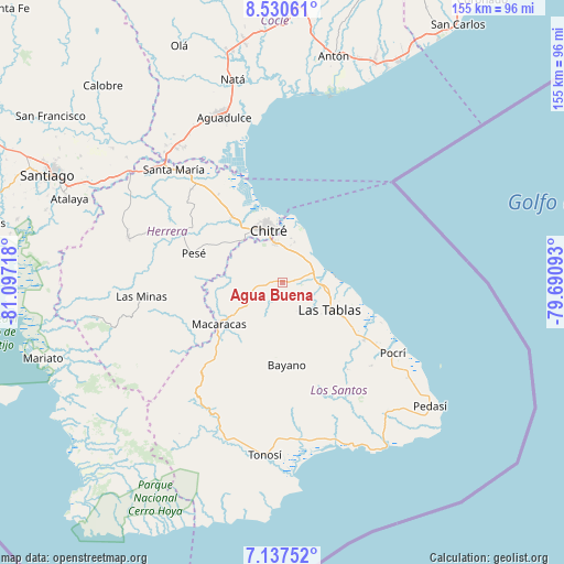
Agua Buena GPS coordinates[2]
7° 50' 4.74" North, 80° 23' 38.58" West
| Map corner | latitude | longitude |
|---|---|---|
| Upper-left | 8.53061°, | -81.09718° |
| Center: | 7.83465°, | -80.39405° |
| Lower-right: | 7.13752°, | -79.69093° |
| Map W x H: | 154.9×154.9 km | = 96.3×96.3mi |
| max Lat: | 9.60898° ⇑88.3% North |
| Agua Buena: | 7.83465° |
| min Lat: | ⇓11.7% South 7.26534° |
| min Long | Agua Buena | max Long |
| -82.91275° | -80.39405° | -77.38965° |
| W 57.9%⇐ | ⇒42.1% E |
Elevation
Elevation of Agua Buena is 69 m = 226 ft, and this is 103.1 m = 338 ft below average elevation for this country.
| Max E: |
2103 m = 6900 ft | 51.5% |
| Avg. | 172.1 m = 565 ft | |
| Agua Buena | 69 m = 226 ft | |
Min E: |
-1 m = -3 ft | 48.5% |
See also: Panama elevation on elevation.city.
Geographical zone
Agua Buena is located in North Torrid zone (between Equator and Tropic of Cancer). Distance of Equator is 871.1 km =541.3 mi to South.| Distance of | km | miles | from Agua Buena |
|---|---|---|---|
| North Pole | 9135.9 | 5676.8 | to North |
| Arctic Circle | 6530 | 4057.6 | to North |
| Tropic Cancer | 1734.8 | 1078 | to North |
| Equator | 871.1 | 541.3 | to South |


Nearby cities:
15 places around Agua Buena: (largest is in red/bold)
• El Ejido
9.1 km =5.7 mi,  4°
4°
• El Espinal
9 km =5.6 mi,  66°
66°
• El Hato
4.8 km =3 mi,  164°
164°
• Guararé Arriba
5.4 km =3.4 mi,  135°
135°
• La Espigadilla
5.5 km =3.4 mi, 4°
• La Pasera
10.8 km =6.7 mi,  112°
112°
• Las Cruces
4.2 km =2.6 mi,  251°
251°
• Llano Abajo
5.7 km =3.5 mi,  198°
198°
• Llano Largo
8.7 km =5.4 mi,  336°
336°
• Los Santos
11.3 km =7 mi,  347°
347°
• Los Ángeles
6.8 km =4.2 mi,  35°
35°
• Perales
10.1 km =6.3 mi,  131°
131°
• Sabana Grande
3.2 km =2 mi,  88°
88°
• Tres Quebradas
1.6 km =1 mi,  292°
292°
• Villa Lourdes
8.8 km =5.5 mi, 252°
Sources, notices
• [Note1] Compared only with cities in Panama existing in our database
• [Src1] Map data: © OpenStreetMap contributors (CC-BY-SA)
• [Src2] Other city data from geonames.org with taken over terms of usage.
• [Src3] Geographical zone / Annual Mean Temperature by Robert A. Rohde @ Wikipedia
