Tres Quebradas geodata
Tres Quebradas (Los Santos) is a seat of a third-order administrative division; located in Panama in America/Panama (GMT-5) time zone. With population of 715 people, there are 348 cities with bigger population in this country. Compared to other cities in Panama, 88% of cities are located further ↑North; 57.2% of cities are located further ←West and 53.3% of cities have higher elevation than Tres Quebradas. Note1


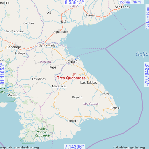
Tres Quebradas GPS coordinates[2]
7° 50' 24.648" North, 80° 24' 26.64" West
| Map corner | latitude | longitude |
|---|---|---|
| Upper-left | 8.53613°, | -81.11053° |
| Center: | 7.84018°, | -80.4074° |
| Lower-right: | 7.14306°, | -79.70428° |
| Map W x H: | 154.9×154.9 km | = 96.3×96.3mi |
| max Lat: | 9.60898° ⇑88% North |
| Tres Quebradas: | 7.84018° |
| min Lat: | ⇓12% South 7.26534° |
| min Long | Tres Quebradas | max Long |
| -82.91275° | -80.4074° | -77.38965° |
| W 57.2%⇐ | ⇒42.8% E |
Elevation
Elevation of Tres Quebradas is 65 m = 213 ft, and this is 107.1 m = 351 ft below average elevation for this country.
| Max E: |
2103 m = 6900 ft | 53.3% |
| Avg. | 172.1 m = 565 ft | |
| Tres Quebradas | 65 m = 213 ft | |
Min E: |
-1 m = -3 ft | 46.7% |
See also: Panama elevation on elevation.city.
Geographical zone
Tres Quebradas is located in North Torrid zone (between Equator and Tropic of Cancer). Distance of Equator is 871.7 km =541.6 mi to South.| Distance of | km | miles | from Tres Quebradas |
|---|---|---|---|
| North Pole | 9135.3 | 5676.4 | to North |
| Arctic Circle | 6529.4 | 4057.2 | to North |
| Tropic Cancer | 1734.2 | 1077.6 | to North |
| Equator | 871.7 | 541.6 | to South |


Nearby cities:
15 places around Tres Quebradas: (largest is in red/bold)
• Agua Buena
1.6 km =1 mi,  112°
112°
• El Ejido
8.8 km =5.5 mi,  14°
14°
• El Espinal
10.1 km =6.3 mi,  73°
73°
• El Hato
5.9 km =3.7 mi,  152°
152°
• Guararé Arriba
6.9 km =4.3 mi,  130°
130°
• La Espigadilla
5.2 km =3.2 mi,  21°
21°
• Las Cruces
3.2 km =2 mi,  232°
232°
• Las Guabas
10.8 km =6.7 mi,  254°
254°
• Llano Abajo
6 km =3.7 mi,  183°
183°
• Llano Largo
7.6 km =4.7 mi,  344°
344°
• Los Santos
10.4 km =6.5 mi,  354°
354°
• Los Ángeles
7.3 km =4.5 mi,  48°
48°
• Sabana Grande
4.7 km =2.9 mi,  96°
96°
• Santa Ana Arriba
11.4 km =7.1 mi,  25°
25°
• Villa Lourdes
7.6 km =4.7 mi, 245°
Sources, notices
• [Note1] Compared only with cities in Panama existing in our database
• [Src1] Map data: © OpenStreetMap contributors (CC-BY-SA)
• [Src2] Other city data from geonames.org with taken over terms of usage.
• [Src3] Geographical zone / Annual Mean Temperature by Robert A. Rohde @ Wikipedia
