La Pintada geodata
La Pintada (Coclé) is a seat of a second-order administrative division; located in Panama in America/Panama (GMT-5) time zone. With population of 1,917 people, there are 127 cities with bigger population in this country. Compared to other cities in Panama, 63.5% of cities are located further ↓South; 55.2% of cities are located further ←West and 51.5% of cities have higher elevation than La Pintada. Note1


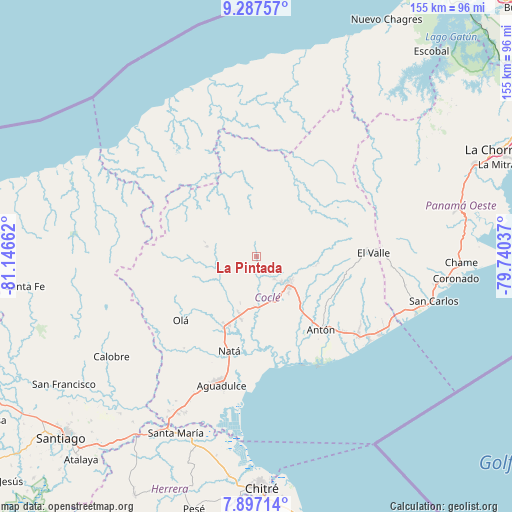
La Pintada GPS coordinates[2]
8° 35' 34.764" North, 80° 26' 36.564" West
| Map corner | latitude | longitude |
|---|---|---|
| Upper-left | 9.28757°, | -81.14662° |
| Center: | 8.59299°, | -80.44349° |
| Lower-right: | 7.89714°, | -79.74037° |
| Map W x H: | 154.6×154.6 km | = 96.1×96.1mi |
| max Lat: | 9.60898° ⇑36.5% North |
| La Pintada: | 8.59299° |
| min Lat: | ⇓63.5% South 7.26534° |
| min Long | La Pintada | max Long |
| -82.91275° | -80.44349° | -77.38965° |
| W 55.2%⇐ | ⇒44.8% E |
Elevation
Elevation of La Pintada is 69 m = 226 ft, and this is 103.1 m = 338 ft below average elevation for this country.
| Max E: |
2103 m = 6900 ft | 51.5% |
| Avg. | 172.1 m = 565 ft | |
| La Pintada | 69 m = 226 ft | |
Min E: |
-1 m = -3 ft | 48.5% |
See also: Panama elevation on elevation.city.
Geographical zone
La Pintada is located in North Torrid zone (between Equator and Tropic of Cancer). Distance of Equator is 955.5 km =593.7 mi to South.| Distance of | km | miles | from La Pintada |
|---|---|---|---|
| North Pole | 9051.6 | 5624.4 | to North |
| Arctic Circle | 6445.7 | 4005.2 | to North |
| Tropic Cancer | 1650.5 | 1025.6 | to North |
| Equator | 955.5 | 593.7 | to South |


Nearby cities:
15 places around La Pintada: (largest is in red/bold)
• Bella Vista
6.9 km =4.3 mi,  144°
144°
• Cañaveral
8.6 km =5.3 mi,  169°
169°
• Chigoré
12.3 km =7.6 mi,  124°
124°
• El Potrero
11.3 km =7 mi,  225°
225°
• Las Delicias
10.3 km =6.4 mi, 123°
• Las Lomas
12.2 km =7.6 mi, 140°
• Las Minas
7.6 km =4.7 mi,  45°
45°
• Llano Grande
5.1 km =3.2 mi,  6°
6°
• Los Uveros
8.9 km =5.5 mi, 143°
• Machuca
11.9 km =7.4 mi,  285°
285°
• Penonomé
12.6 km =7.8 mi,  130°
130°
• Piedras Gordas
8.9 km =5.5 mi,  304°
304°
• Sonadora
13.6 km =8.5 mi,  109°
109°
• Toabré
15 km =9.3 mi,  64°
64°
• Vista Hermosa
10.5 km =6.5 mi, 134°
Sources, notices
• [Note1] Compared only with cities in Panama existing in our database
• [Src1] Map data: © OpenStreetMap contributors (CC-BY-SA)
• [Src2] Other city data from geonames.org with taken over terms of usage.
• [Src3] Geographical zone / Annual Mean Temperature by Robert A. Rohde @ Wikipedia
