Guzman geodata
Guzman (Coclé) is a seat of a third-order administrative division; located in Panama in America/Panama (GMT-5) time zone. With population of 228 people, there are 591 cities with bigger population in this country. Compared to other cities in Panama, 55.2% of cities are located further ↓South; 50.3% of cities are located further ←West and 67.6% of cities have lower elevation than Guzman. Note1


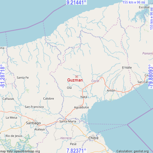
Guzman GPS coordinates[2]
8° 31' 10.884" North, 80° 35' 2.58" West
| Map corner | latitude | longitude |
|---|---|---|
| Upper-left | 9.21441°, | -81.28718° |
| Center: | 8.51969°, | -80.58405° |
| Lower-right: | 7.82371°, | -79.88093° |
| Map W x H: | 154.6×154.6 km | = 96.1×96.1mi |
| max Lat: | 9.60898° ⇑44.8% North |
| Guzman: | 8.51969° |
| min Lat: | ⇓55.2% South 7.26534° |
| min Long | Guzman | max Long |
| -82.91275° | -80.58405° | -77.38965° |
| W 50.3%⇐ | ⇒49.7% E |
Elevation
Elevation of Guzman is 138 m = 453 ft, and this is 34.1 m = 112 ft below average elevation for this country.
| Max E: |
2103 m = 6900 ft | 32.4% |
| Avg. | 172.1 m = 565 ft | |
| Guzman | 138 m = 453 ft | |
Min E: |
-1 m = -3 ft | 67.6% |
See also: Panama elevation on elevation.city.
Geographical zone
Guzman is located in North Torrid zone (between Equator and Tropic of Cancer). Distance of Equator is 947.3 km =588.6 mi to South.| Distance of | km | miles | from Guzman |
|---|---|---|---|
| North Pole | 9059.8 | 5629.5 | to North |
| Arctic Circle | 6453.9 | 4010.3 | to North |
| Tropic Cancer | 1658.6 | 1030.6 | to North |
| Equator | 947.3 | 588.6 | to South |


Nearby cities:
15 places around Guzman: (largest is in red/bold)
• Barranco Colorado
15.6 km =9.7 mi,  201°
201°
• Cañaveral
17 km =10.6 mi,  91°
91°
• Churubé Abajo
14.2 km =8.8 mi,  160°
160°
• Ciruelito
16.5 km =10.3 mi,  116°
116°
• El Caño
15 km =9.3 mi,  150°
150°
• El Copé
11.2 km =7 mi,  359°
359°
• El Copé
13.9 km =8.6 mi,  228°
228°
• El Potrero
7.4 km =4.6 mi, 88°
• La Candelaria
13.7 km =8.5 mi,  130°
130°
• Las Sabanas
12.6 km =7.8 mi,  303°
303°
• Machuca
12 km =7.5 mi,  19°
19°
• Nuestro Amo
8.3 km =5.2 mi,  183°
183°
• Olá
13.5 km =8.4 mi,  213°
213°
• Piedras Gordas
15.4 km =9.6 mi,  31°
31°
• Río Grande
15 km =9.3 mi, 133°
Sources, notices
• [Note1] Compared only with cities in Panama existing in our database
• [Src1] Map data: © OpenStreetMap contributors (CC-BY-SA)
• [Src2] Other city data from geonames.org with taken over terms of usage.
• [Src3] Geographical zone / Annual Mean Temperature by Robert A. Rohde @ Wikipedia
