El Copé geodata
El Copé (Coclé) is a seat of a third-order administrative division; located in Panama in America/Panama (GMT-5) time zone. With population of 190 people, there are 607 cities with bigger population in this country. Compared to other cities in Panama, 54.2% of cities are located further ↑North; 54.2% of cities are located further →East and 84.9% of cities have lower elevation than El Copé. Note1


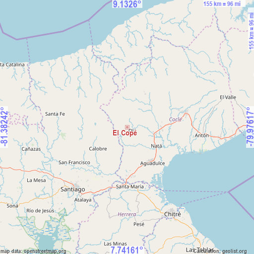
El Copé GPS coordinates[2]
8° 26' 15.828" North, 80° 40' 45.444" West
| Map corner | latitude | longitude |
|---|---|---|
| Upper-left | 9.1326°, | -81.38242° |
| Center: | 8.43773°, | -80.67929° |
| Lower-right: | 7.74161°, | -79.97617° |
| Map W x H: | 154.7×154.7 km | = 96.1×96.1mi |
| max Lat: | 9.60898° ⇑54.2% North |
| El Copé: | 8.43773° |
| min Lat: | ⇓45.8% South 7.26534° |
| min Long | El Copé | max Long |
| -82.91275° | -80.67929° | -77.38965° |
| W 45.8%⇐ | ⇒54.2% E |
Elevation
Elevation of El Copé is 338 m = 1109 ft, and this is 165.9 m = 544 ft above average elevation for this country.
| Max E: |
2103 m = 6900 ft | 15.1% |
| El Copé | 338 m 1109 ft | |
| Avg. | 172.1 m = 565 ft | |
Min E: |
-1 m = -3 ft | 84.9% |
See also: Panama elevation on elevation.city.
Geographical zone
El Copé is located in North Torrid zone (between Equator and Tropic of Cancer). Distance of Equator is 938.2 km =583 mi to South.| Distance of | km | miles | from El Copé |
|---|---|---|---|
| North Pole | 9068.9 | 5635.2 | to North |
| Arctic Circle | 6463 | 4015.9 | to North |
| Tropic Cancer | 1667.7 | 1036.3 | to North |
| Equator | 938.2 | 583 | to South |


Nearby cities:
15 places around El Copé: (largest is in red/bold)
• Barnizal
11.4 km =7.1 mi,  251°
251°
• Barranco Colorado
7.2 km =4.5 mi,  138°
138°
• Churubé Abajo
15.8 km =9.8 mi,  105°
105°
• El Caño
18.2 km =11.3 mi,  102°
102°
• El Cortezo
14.4 km =8.9 mi, 135°
• El Potrero
14.3 km =8.9 mi,  241°
241°
• Guzman
13.9 km =8.6 mi,  48°
48°
• La Laguna
12.3 km =7.6 mi,  206°
206°
• La Yeguada
19.6 km =12.2 mi,  267°
267°
• Las Huacas del Quije
8.5 km =5.3 mi,  292°
292°
• Las Sabanas
16 km =9.9 mi,  359°
359°
• Nuestro Amo
9.9 km =6.2 mi,  85°
85°
• Olá
3.8 km =2.4 mi,  125°
125°
• San José
14.2 km =8.8 mi,  283°
283°
• Toza
11.1 km =6.9 mi,  157°
157°
Sources, notices
• [Note1] Compared only with cities in Panama existing in our database
• [Src1] Map data: © OpenStreetMap contributors (CC-BY-SA)
• [Src2] Other city data from geonames.org with taken over terms of usage.
• [Src3] Geographical zone / Annual Mean Temperature by Robert A. Rohde @ Wikipedia
